10 Swan Bay - Embayment Infills and Delta
|
This information has been developed from one or more of these publications:
|
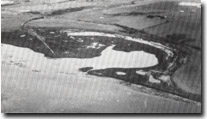
Location | 928638. Southwestern coast of Swan Bay. |  Site 10, Yarram Creek delta infilling part of Swan Bay |
Access | Knights Road off Portarlington - Queenscliff Road, 2 km north of the Bellarine Highway. | |
Ownership/Managing Authority | Private land and some Crown land. (Department of Conservation Forests and Lands). | |
Site Description | A shallow embayment with a constricted tidal entrance is partly filled by, and fringed with, salt marshes. Yarram Creek empties into the embayment through an elongate delta with several distributaries. The embayment is backed by a high bluff which swings inland to the north and becomes lower behind a low ridged foreland. The coast is fringed by tall shrubland of Sclerostegia arbuscula (Shrubby Glasswort) and there are dense mats of seagrass hay and abundant shells. There are apparently no mangroves here. | |
Significance | Regional. The site demonstrates the process of embayment infill in a vigorous salt marsh growth environment. It is one of the most extensive salt marsh sites in Port Phillip Bay and is important to demonstrate the role of organic materials (shells, seagrass and salt marsh) in prograding sheltered coastlines. Yarram Creek delta is the best example of a distributary delta in Port Phillip Bay. | |
Management Considerations | Class 1. Dredging, further drainage, or infill of the site would destroy the significant features. Maintaining the wetland areas as a waterbird refuge would be a suitable means of retaining the geomorphological character of the site. | |

Site 10, Swan Bay shore and delta of Yarram Creek


