
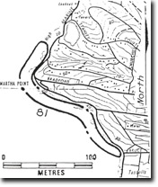
81 Martha Point East - Shore Platforms
|
This information has been developed from one or more of these publications:
|
| Location | 243585. Northern coast of Dromana Bay southeast from Martha Point to Bruce Road. | |
Access | Marine Drive at the western end of Bruce Road. The site is best accessed by walking north from the parking area at the western end of Bruce Road. Some of the main features of the site are visible only during low tide. | |
Ownership/Managing Authority | Crown land, Shire of Mornington and Shire of Flinders. | |
Site Description | The site lies at the southern edge of Mt Martha pluton, a small intrusive body of hornblende granodiorite. The rock is more deeply weathered at the northern and southern margins of the intrusion where it is overlain by Tertiary sediments, while fresher rock is exposed at the coast north of Martha Point. Examples of granodiorite lithology, xenoliths, aplite veins and grades of weathering, are clearly displayed. The coastal profile and the extent of shore platform development vary towards the north deepening on the degree of weathering of the rock. Broad shore platforms averaging 25 m wide occur southeast of Martha Point, the widest and most continuous being at the southern end north of Bruce Road. The platform slopes gently seaward at the cliff base, becoming level beyond this although it is interrupted by narrow gutters or ribs of less weathered rock which protrude as ridges and form small stacks. Rounded granite boulders lie strewn on the platform and form gravel beaches in some small embayments. In the less weathered rock near Martha Point, here is not shore platform and the coast has an irregular and indented form. However, at the cliff base, there is a discontinuous ledge up to 1 m above high water mark which earlier workers interpreted as a remnant, emerged platform (formed at a stage of higher sea level). | |
Significance | State. The site is one of the few shore platforms in Victoria that have developed in granitic rock. It is therefore unusual in the context of state geomorphological features and demonstrates the influence of weathering in coastal landform development. The site has been studied in detail by previous workers and a model developed of the stages and processes of platform development. Differing views have been offered to account for the profile form, especially the ledge of bench above high water mark. It is an excellent interpretation site and its preservation intact is desirable. | |
Management Considerations | Class 2. The site should not be modified. Engineering or construction works and beach nourishment schemes should not be undertaken. Cliff walkways and parking provision along The Esplanade would facilitate access to some parts of the site. | |
References | Jutson, J.T. (1940) Hills, E.S. (1940) Keble, R.A. (1950) Hills, E.S. (1971) | |

© State of Victoria (Agriculture Victoria) 1996 - .

This work, Victorian Resources Online, is licensed under a Creative Commons Attribution 4.0 licence. You are free to re-use the work under that licence, on the condition that you credit the State of Victoria (Agriculture Victoria) as author, indicate if changes were made and comply with the other licence terms.
The licence does not apply to ‘branding’ or some ‘images or photographs’ that may be owned by third parties. We ask you to seek prior approval to use images using the VRO feedback form. Access to higher quality images can also be provided on request.
This page was last updated on .