
80 Mount Martha - Sedimentary Raft
|
This information has been developed from one or more of these publications:
|
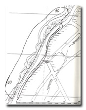
| Location | 608245. Road cuttings of the Esplanade, Mt Martha beginning approximately 100 m south of Finlayson Ave and extending 300 m south. The site includes the slopes and coastline below the road. | 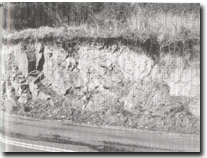 Site 80, Mt Martha sedimentary raft |
Access | The Esplanade, Mt Martha. | |
Ownership/Managing Authority | Crown land (Road Reserve), Shire of Mornington. | |
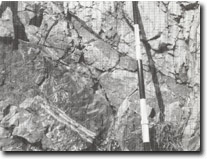
Site Description | The road cutting exposes a block of altered Palaeozoic sediments enclosed in the Mt Martha Granodiorite. The structure is termed a ‘raft’. The beds are folded into a shallow anticline and towards the southern end of the cutting (closest to Finlayson Ave), show metamorphic and other alteration features where they contact the granodiorite. These include development of metamorphic hornfels, small faults, intricate jointing, and veins of aplite 10 to 15 cm wide. A larger aplite dyke 70 cm wide, injected almost parallel to the bedding planes of the sediments, is intersected by a high angle reverse fault. The southern cutting (250 m to the south) has a banded hornfels due to an unusual series of narrow, parallel injections of granite along the original bedding planes of the sediment. This cutting is now mainly obscured by soil slumping. | |
The base of the sedimentary raft occurs in the coastal slopes below the road about 6 m above sea level but is difficult to determine owing to vegetation and soil slumping. However, along the coastline below the road cuttings there are other significant exposures of sedimentary blocks contained in the granite. The granite/sediment contact is very clearly displayed on the surface of an irregular platform behind a ridge of granite. Close jointing in the granite has led to an intricate weathering pattern. There are remnants of earlier formed platforms and cliffs at a higher level than the active platforms. | ||
Significance | State. The site is an outstanding example of large sediment blocks that have not been absorbed by the intruding magma. The granite/sediment contacts are very clear, especially in the shore platform exposures. The road cuttings are a clear display of fine-grained aplite intrusions. The site constitutes the only exposure of Palaeozoic sedimentary rock on the coast of Port Phillip Bay. There are a number of well preserved (apparent) higher sea level features. | |
Management Considerations | Class 2. The cutting should be maintained as a geological exposure. Any road widening or realignment should be planned so as to maintain or enhance the exposure of the sedimentary structures in both cuttings. Rock spoil should not be dumped over the road edge onto the coast as this would contaminate the significant exposures here. No engineering, or construction or quarrying operations should be permitted in the site area. | |
References | Keble, R.A. (1950). | |
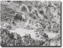 Site 80, Details of aplite intrusions, Mt Martha sedimentary raft | 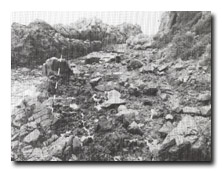 Site 80, Small sediment block enclosed in granite, Mt Martha coast below Finlayson Ave. (Pole shows contact) |
 Site 80, Apparent higher level platform in granite, Mt Martha, below Finlayson Ave. |

© State of Victoria (Agriculture Victoria) 1996 - .

This work, Victorian Resources Online, is licensed under a Creative Commons Attribution 4.0 licence. You are free to re-use the work under that licence, on the condition that you credit the State of Victoria (Agriculture Victoria) as author, indicate if changes were made and comply with the other licence terms.
The licence does not apply to ‘branding’ or some ‘images or photographs’ that may be owned by third parties. We ask you to seek prior approval to use images using the VRO feedback form. Access to higher quality images can also be provided on request.
This page was last updated on .