
29 Curlewis - Platforms, Limestone and Older Volcanics
|
This information has been developed from one or more of these publications:
|
| Location | 836735 to 815732. Shore platforms and some coastal cliffs extending 500 m east and 2 km west of Scarborough Road. | 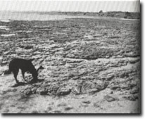 Site 29, Lapillaceous tuff forming wide shore platform near Scarborough Road |
Access | Scarborough Road. | |
Ownership/Managing Authority | Crown land (Port of Geelong Authority) below high water mark; private land above high water mark. | |
Site Description | This long coastal sector exposes an important sequence of the Tertiary geology of the Bellarine Peninsula. The coast is backed by a sloping bluff with some low cliffed and eroding sectors, but the most significant geological features are on the shore platforms and exposed only at low tide. Older Volcanic rocks, Moorabool Viaduct Formation limestones and Fyansford Formation limestones and marine clays outcrop in close proximity on the shore platform, and their stratigraphical relationship is a matter of great interest. The morphology of the shore platforms is also of significance. The volcanic rocks, predominantly a capillaceous tuff, outcrop more or less continuously along the site although in the coastal bluff they are deeply weathered. At the end of Scarborough Road, they form a 100 m wide shore platform with an irregular surface due to the persistent seaward dip of the beds. Some beds stand as low ridges above the general platform level, the crest of the ridge curving as the strike on the beds changes direction. This dip is a clear expression of the northerly downthrow of the Curlewis Monocline. The platforms are nearly horizontal with only a gentle inclination at the seaward margin. The tuff beds in the cliffs and bluffs of this coastal sector are deeply weathered to grey, brown and yellow clays. | |
An important sequence of limestone beds and clays outcrop in the intertidal zone just east of Hermsley Road. They are regarded as a unit (Curlewis Limestone) of the Fyansford Formation. The beds are similar to those at Clifton Springs and include a resistant yellow limestone bed which outcrops along a strike length of almost 400 m. The bed dips north at between 10o and 35o, and includes a shoreline outcrop in a low cliff 250 m west of Hermsley Road. In the intertidal zone, the band is very hard and forms a prominent arcuate reef east and west of the low cliff and acts as an effective breakwater. The outcrop in the cliff is less indurated. Both the limestone and the clays are richly fossiliferous with gastropods, bivalves, Bryozoa and foraminifera. Pyrite and Marcasite occur as nodules in the bluff clay along with gypsum. This group of hard limestones have been designated the ‘Eastern reef’. The shore platform surface is more complex in the Curlewis Limestone than the adjacent volcanic beds. | ||
Significance | State. The site includes a major exposure of the Older Volcanics tuff beds and the Curlewis Limestone. The latter richly fossiliferous unit has an uncertain stratigraphic status and is an important sedimentary sequence in determining the Tertiary stratigraphy of the Bellarine Peninsula. There are numerous geomorphological attributes to the site including the wide shore platforms, the different stages of activity of cliffs and bluffs and the cause of the induration of the limestone beds that forms the reefs. The role of these reefs in determining patterns of wave action and erosion and sedimentation along the coast needs further investigation. The shore platforms are some of the widest that occur in Port Phillip Bay and are significant examples of the variation of platform surfaces that occur due to changes in lithology. The site is an excellent teaching and research site for advanced studies in earth science. | |
Management Considerations | Class 1. The platforms, reefs, and the cliff with the limestone outcrop, should be preserved as geological features. They are relatively fragile features. Reclamation of intertidal areas, building of causeways, jetties, or launching ramps, dredging, blasting or clearing of channels for mooring or boat access, will seriously degrade the site by interrupting the continuity of the limestone reef and obscuring the nature of the structure and destroying fossil localities. There is an urgent need for control of these activities which are at present degrading the site - in particular, dredging and damage to the reef by cutting boat access channels and building private jetties across the intertidal zone. The action of private property holders in dumping boulders to form protective seawalls is introducing foreign materials to the shore (ie - the Public Land Zone). This degrades the geological integrity of the site which urgently requires a comprehensive management strategy. | |
References | Hall, T.S. & Pritchard G.B. (1894) Coulson, A. (1938) Ladd, P.G. (1971) Bajraszewski, O.P. (1977) | |
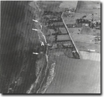 Site 29, Dipping tuff beds (folded along Curlewis Monocline) near Scarborough Road | 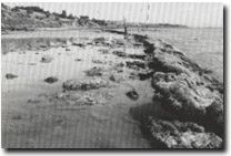 Site 29, Dipping limestone beds (arrowed) at Curlewis near Hermsley Road. The building of private jetties such as at (A), causes damage to the reef | 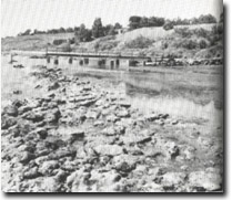 Site 29, Private jetty and ramp across limestone reef west of Hermsley Road. Such structures damage the geological features of this significant site. Monitoring private developments that infringe on public land containing important geological features is urgently required here, as it is at many other sites around Port Phillip Bay |
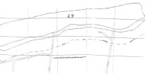 Site 29, Curlewis, shore platforms, limestone and Older Volcanics, Scarborough Road |

© State of Victoria (Agriculture Victoria) 1996 - .

This work, Victorian Resources Online, is licensed under a Creative Commons Attribution 4.0 licence. You are free to re-use the work under that licence, on the condition that you credit the State of Victoria (Agriculture Victoria) as author, indicate if changes were made and comply with the other licence terms.
The licence does not apply to ‘branding’ or some ‘images or photographs’ that may be owned by third parties. We ask you to seek prior approval to use images using the VRO feedback form. Access to higher quality images can also be provided on request.
This page was last updated on .