
13 The Bluff (Miller Point) - Active Cliff
|
This information has been developed from one or more of these publications:
|
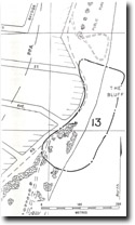
| Location | 997771. 1 km south of St Leonards Jetty. | 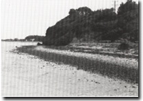 Site 13, The Bluff (Miller Point), St Leonards |
Ownership/Managing Authority | Crown land, Public Purposes Reserve (St Leonards Foreshore Committee of Management). | |
Site Description | The Bluff is an active marine cliff cut into mottled red and brown ferruginous sands and sandy clays of the Moorabool Viaduct Sand. The rock outcrops along a distance of 100 m with about half this length being washed by high tide. To the north, the cliff swings inland to become a degraded bluff fronted by a terrace of sand and shell ridges. The base of the cliff is undercut in places but the rate of cliff retreat must be slow. A platform with a veneer of sand, shell and gravel lies in front of the cliff sector. Erosion of the cliff contributes to the material drifting southward to nourish the eastern beaches of the Edwards Point complex. | |
Significance | Local. The site is a very clear example of a small coastal/bluff system, where a formerly active cliff has become isolated from marine erosion by accumulation of sediment. This cliff is the only active segment of the long bluff that lies inland of Swan Bay (refer Sites 10 & 11), and allows understanding of the coastal conditions of Swan Bay before the development of the Swan Island/Edwards Point Barriers. It is the most southerly coastal exposure of Moorabool Viaduct Sand on the Bellarine Peninsula. | |
Management Considerations | Class 2. The system is currently well managed to allow conservation and display the geologically significant features. The cliff is not an erosion hazard, it is not dangerous and erosion rates do not pose a threat to property. There should be no engineering works constructed, either as protective or stabilization measures, and beach nourishment should not be undertaken at, or adjacent to the site. The bluff and the terraces to the north and south of the active cliff sector are an important part of the site and should be kept clear of further reclamation and building. | |
Site 13, The Bluff (Miller Point)

© State of Victoria (Agriculture Victoria) 1996 - .

This work, Victorian Resources Online, is licensed under a Creative Commons Attribution 4.0 licence. You are free to re-use the work under that licence, on the condition that you credit the State of Victoria (Agriculture Victoria) as author, indicate if changes were made and comply with the other licence terms.
The licence does not apply to ‘branding’ or some ‘images or photographs’ that may be owned by third parties. We ask you to seek prior approval to use images using the VRO feedback form. Access to higher quality images can also be provided on request.
This page was last updated on .