
85 Point McArthur - Cemented Band in Calcarenite
|
This information has been developed from one or more of these publications:
|
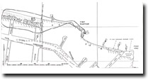
| Location | 019557. Western side of Port McArthur, 400 m west of Point King. The site is immediately west of a set of (private) wooden steps leading to the beach. | 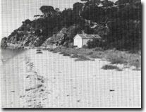 Site 85, Calcarenite beds at Point McArthur |
| Access | Point King road and footpath to beach. | |
| Ownership/Managing Authority | Private land at Point McArthur. Public land (Portsea Foreshore Trust Committee of Management) for the sandy terrace at Collins Bay. | |
Site Description | Point McArthur is a calcarenite headland with clearly displayed typical acolianite features, such as cross bedding, pitting, differential weathering and buried soils. Extending around the western side of the pint, and resting about 1 m above high water mark is a 60 to 70 cm thick horizontal band of cemented calcarenite. This band is independent of dune bedding and structures. The band has been interpreted as a layer of secondary cementation induced by deposition of calcium carbonate from a freshwater lens lying in the dunes above the high water mark. The elevation of this band, (about 1 m above present high water level) suggests that the sea stood at this higher level (possibly in the mid-Holocene). To the west of the point, the cliff is fronted by a wide sandy depositional terrace that extends towards Point Franklin. The upper surface of this terrace is only a little below the level of the cemented band. | |
Significance | State. This is one of a number of sites in Port Phillip Bay that have been interpreted as indicating a higher Holocene sea level. The site was first described by the late Professor E.S. Hills, one of the most significant figures in the development of geomorphological studies in Victoria. The terrace to the west of Point McArthur is an unusually broad sand accumulation feature and its level may be related to the development of the cemented band. This terrace may once have extended as a foreland from Point King to Point Franklin thus enclosing Point McArthur. | |
Management Considerations | Class 1. The cemented calcarenite band should be left exposed and kept free from building or protective structures. The calcarenite cliffs should not be reclaimed or further built over by public or private structures. No further buildings or reclamation should be permitted on the outer margin of the beach terrace. | |
References | Hills, E.S. (1940) | |
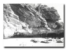 Site 85, Cemented band (1 m on ranging pole) in calcarenite, Point McArthur | 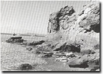 Site 85, Cemented band in calcarenite, Point McArthur |
 Site 85, Point McArthur cemented band (arrow), and terrace at Collins Bay |

© State of Victoria (Agriculture Victoria) 1996 - 2025.

This work, Victorian Resources Online, is licensed under a Creative Commons Attribution 4.0 licence. You are free to re-use the work under that licence, on the condition that you credit the State of Victoria (Agriculture Victoria) as author, indicate if changes were made and comply with the other licence terms.
The licence does not apply to ‘branding’ or some ‘images or photographs’ that may be owned by third parties. We ask you to seek prior approval to use images using the VRO feedback form. Access to higher quality images can also be provided on request.
This page was last updated on 23/11/2018.