
21 Point Richards - Cuspate Foreland
|
This information has been developed from one or more of these publications:
|
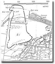
| Location | 921794. 2 km west of the Portarlington Jetty. The boundaries of the site shown are approximate, in that they enclose an area with a number of scientific features. Because of the disturbed nature of the site, a specific investigation is required to determine discrete areas with relatively intact and discernible features. | 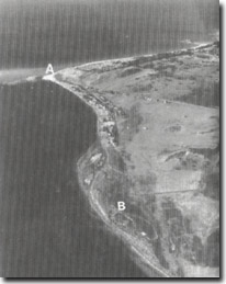 Site 21, Point Richards (A), and Site 22, Point Richards South (B). The lobate area of Site 22 may be an earlier stage in the growth of Point Richards |
Access | Point Richards Road. | |
Ownership/Managing Authority | Crown land (Portarlington Foreshore Committee of Management and Department of Conservation, Forests and Lands). The site includes a Flora and Fauna Reserve. | |
Site Description | Point Richards or ‘Richards Foreland’, is a large, triangular sand accumulation feature that projects over 1 km seaward of a bluff that marks the pre-depositional cliffed coastline. The foreland has prograded by extensive sand depositions in the form of broad, low and irregular sand ridges interspersed with low-lying swamp depressions. At the base of the foreland, these depressions contain lakes. The specific modes of sand accumulation ie - the role of the bar migration, development of barriers, beach ridges and dunes, has not been investigated in detail. Also unknown is the relationship of the feature to Holocene sea level changes. The northern and eastern edges of the foreland have wide beaches and it is apparent that sand drifts towards and accumulates at this point. | |
Significance | Regional. The foreland is the largest single sand accumulation feature on the Port Phillip Bay coast. It has been a persistent site of progradation - even over the past few decades - and illustrates a dominant westward movement of sand at Portarlington. | |
Management Considerations | Class 2. The topography of the feature has been considerably altered and it is difficult to isolate segments that have retained substantial natural values. This difficulty is compounded by the beach nourishment schemes that have taken place at Portarlington which have contributed sediments to the Point Richards beach. The components of the site - the bluff, lagoons, ridges, swamps, and beach - are separated by intervening developments, (drainage, residential and holiday accommodation, car parks, sand stockpiles), to such an extent that a comprehensive scientific management programme for the feature requires more detailed study. It is recommended that such a study be commissioned before further reclamation of these components occur. | |
References | Bird, E.C.F (1980) Bowler, J.M. (1966) Jutson, J.T. (1931) | |
Site 21, Point Richards

© State of Victoria (Agriculture Victoria) 1996 - .

This work, Victorian Resources Online, is licensed under a Creative Commons Attribution 4.0 licence. You are free to re-use the work under that licence, on the condition that you credit the State of Victoria (Agriculture Victoria) as author, indicate if changes were made and comply with the other licence terms.
The licence does not apply to ‘branding’ or some ‘images or photographs’ that may be owned by third parties. We ask you to seek prior approval to use images using the VRO feedback form. Access to higher quality images can also be provided on request.
This page was last updated on .