
24 McAdams Lane - Landslip and Geological Site
|
This information has been developed from one or more of these publications:
|
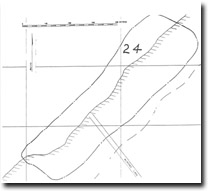
| Location | 875765. Coast extending approximately 500 m north and 200 m south of the end of McAdams Lane, Bellarine. | 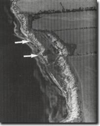 Site 24, Rotational slump cliffs at McAdams Lane |
| Access. | McAdams Lane off Geelong-Portarlington Road, Bellarine | |
| Ownership/Managing Authority | Crown land (Port of Geelong Authority) below high water mark; private land above high water mark. | |
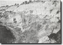
Site Description | The coast is backed by high active cliffs with both marine and subaerial processes evident. There are extensive vertical and horizontal sections of the Moorabool Viaduct Sand and an overlying formation of uncertain age of sandy clays, and occasional gravels. Immediately north of McAdams Lane, there is a double cliff, apparently formed by massive rotational slumping of the beds overlying an impermeable Fyansford Formation clay bed. The outer (coastal) cliff shows an unconformable contact between Moorabool Viaduct Sand and an overlying conglomerate bed 4 m thick which contains Older Basalt boulders up to 20 cm in diameter. Further north, a ridge of northerly dipping limestone projects seaward from the cliff base and rises 2 m above the surface of a rough and irregular shore platform. This outcrop is one of the calcareous beds of the Fyansford Formation (formerly referred to as Curlewis Limestone). The dip is due to tilting along the Curlewis Monocline, the major structure that defines the northern edge of the Bellarine Peninsula. Weathering of this bed has produced minor karst features such as pits and runnels. The Tertiary sedimentary outcrops continue as cliffs with closely spaced rills for 500 m south of McAdams Lane. | |
Significance | State. This is a complex, large and important geological and geomorphological site. It includes some of the highest and most active coastal cliffs in Port Phillip Bay, and has a number of geological contacts as well as varied shore platform and beach morphology. It is of major importance in displaying and interfering the stratigraphy and geomorphological and geological evolution of the Bellarine Peninsula. Of particular importance is the question of the origin of the double cliff, the origin and age of the coarse conglomerate bed, the Fyansford Formation outcrop and the karstic features on the limestone ridges. There are very few places along the coast of Victoria where such a diverse array of features occurs in a compressed area. | |
Management Considerations | Class 2. The coast should be left in its present dynamic condition. There is no danger to property or structures and there should be strict controls on building sites to prevent these being endangered by the normal processes of cliff and coastal evolution. Provision of a pathway to the beach at the end of McAdams Lane would assist excursion groups gaining access to the site. There is no justification for protective engineering structures or beach nourishment at this site. The site should be utilized as a scientific site in anticipation of continuing geomorphological changes. | |
References | Coulson, A. (1933, 1938) Ladd, P.G. (1971) | |
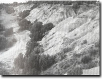 Site 24, Headwall of rotational slump at McAdams Lane | 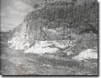 Site 24, McAdams Lane. Conglomerate bed unconformably overlying Moorabool Viaduct Sand | 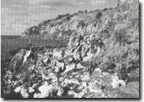 Site 24, McAdams Lane. Limestone weathering at cliff base |
 Site 24, McAdams Lane. Rills in cliff face |

© State of Victoria (Agriculture Victoria) 1996 - .

This work, Victorian Resources Online, is licensed under a Creative Commons Attribution 4.0 licence. You are free to re-use the work under that licence, on the condition that you credit the State of Victoria (Agriculture Victoria) as author, indicate if changes were made and comply with the other licence terms.
The licence does not apply to ‘branding’ or some ‘images or photographs’ that may be owned by third parties. We ask you to seek prior approval to use images using the VRO feedback form. Access to higher quality images can also be provided on request.
This page was last updated on .