
23 Spray Farm Land - Raised Beach
|
This information has been developed from one or more of these publications:
|
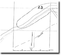
| Location | 901776. Coast adjacent to the end of Spray Farm Lane, Bellarine, 3 km southwest of Point Richards. | 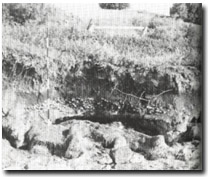 Site 23, Spray Farm Road raised beach deposits |
| Access | Spray Farm Lane, off Geelong-Portarlington Road. | |
| Ownership/Managing Authority | Crown land (Port of Geelong Authority) below high water mark; private land above high water mark. | |
Site Description | Spray Farm Lane ends on a low promontory, formed at the point where the bluff that lies behind Point Richards reaches the coast. To the south of Spray Farm Lane the bluff swings inland behind an infilled embayment. Just west of the land, the terrace filling this embayment has an eroded edge, providing a clear section of the terrace material lying on buried shore platform cut in soft Moorabool Viaduct Sand. The terrace is comprised of a 30 cm thick bed of rounded gravel and broken shell, including well-rounded boulders of quartz and ironstone up to 10 cm long. This material is a beach deposit emplaced approximately 1 m above the level of present day beaches. Overlying this is a dark sand bed (possibly also a beach) and on top of this is a mixed deposit of sand, broken shell and soil. Part of this upper horizon is derived by active hill wash from the bluff. The terrace extends south and becomes swampy at the mouth of a small gully. It is then fringed by a sand beach and low sand ridges. | |
Significance | State. Of particular importance is the beach deposit stranded up to one metre above the level of presently forming beaches. It comprises an excellent example of a deposit which could be interpreted as being indicative of a slightly higher sea level in the mid or late Holocene. The morphology of the bluff and terrace materials therefore make an important interpretation site for the study of former sea levels in Port Phillip Bay. | |
Management Considerations | Class 1. The site should be retained without modification. There is no need for protective structures, as the best way of maintaining the exposure is to allow occasional marine erosion to keep the site clear. Filling, building, excavation, or reclamation of the terrace, or beach nourishment should be not permitted, as these would cover or extensively modify the significant features. | |
References | Ladd, P.G. (1971) | |
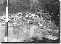 Site 23, Gravels and shells of raised beach deposit, Spray Farm Road |

© State of Victoria (Agriculture Victoria) 1996 - 2025.

This work, Victorian Resources Online, is licensed under a Creative Commons Attribution 4.0 licence. You are free to re-use the work under that licence, on the condition that you credit the State of Victoria (Agriculture Victoria) as author, indicate if changes were made and comply with the other licence terms.
The licence does not apply to ‘branding’ or some ‘images or photographs’ that may be owned by third parties. We ask you to seek prior approval to use images using the VRO feedback form. Access to higher quality images can also be provided on request.
This page was last updated on 23/11/2018.