
4 Queenscliff Isthmus - Parallel Dune Ridges
|
This information has been developed from one or more of these publications:
|
| Location | 934612. Northern shore of Lonsdale Bay, 1.5 km west of the Point Lonsdale Lighthouse. The site includes the area south of the Bellarine Highway. | 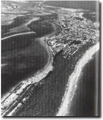 Site 4, Dune ridges forming the isthmus at Queenscliff |
Access | Coastal footpath or beach walk from Bellarine Highway and YMCA Camp. | |
Ownership/Managing Authority | Crown Land, Borough of Queenscliff. | |
Site Description | The northern shore of Lonsdale Bay is backed by parallel dune ridges forming an isthmus linking the calcarenite headlands of Point Lonsdale and Shortlands Bluff. This site represents the least modified example of this terrain. To the west of the site, the ridges are fronted by a boulder or timber seawall and groynes while to the east the topography has been modified for residential and recreational developments. The site is 300 m long extending from low water mark inland to the Bellarine Highway. There are two main scrub-covered dune ridges separated by a well pronounced swale or inter-dune corridor. Seaward to these is a grassy foredune of variable form - in places it is terraced and elsewhere is of incipient ridge form. A pattern of cut and fill is apparent along this coastal sector although it is not known on what time frame this operates. The ridges are linear to gently curving and although they must include a component of wind-blown sand to reach their height, they were apparently initiated as swash aligned ridges. No major blowouts occur across the main ridges although minor active blowouts occur on parts of the seaward dune. | |
Significance | Regional. These are some of the highest sand ridges on the coast of Port Phillip Bay and are a relatively intact example of high parallel ridge form. They indicate a late Holocene phase of sand nourishment to this coastal sector and of interest in sand budget studies of the Queenscliff-Swan Island area. They represent the only site on the west coast (and one of few in Port Phillip Bay) where studies of frontal dune development can be conducted. | |
Management Considerations | Class 2. The dunes should be maintained without protective seawalls or groynes. Techniques for dune nourishment (slat fences, sand traps), should be utilized in attempts to maintain and encourage foredune growth. Built structures that would be endangered by an episode of dune erosion should be excluded from the site. Public pathways across the dunes should be maintained to avoid excessive damage to dune vegetation that may lead to blowout development. In the event of erosion becoming excessive, beach nourishment from offshore is preferable to seawall construction at this site. | |
References | McArthur, J.A. (1978) Bird, E.C.F. (1980) | |
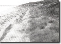 Site 4, Foredune ridge, Lonsdale Bight near Queenscliff |

© State of Victoria (Agriculture Victoria) 1996 - .

This work, Victorian Resources Online, is licensed under a Creative Commons Attribution 4.0 licence. You are free to re-use the work under that licence, on the condition that you credit the State of Victoria (Agriculture Victoria) as author, indicate if changes were made and comply with the other licence terms.
The licence does not apply to ‘branding’ or some ‘images or photographs’ that may be owned by third parties. We ask you to seek prior approval to use images using the VRO feedback form. Access to higher quality images can also be provided on request.
This page was last updated on .