
5 Shortlands Bluff - Calcarenite Beds
|
This information has been developed from one or more of these publications:
|
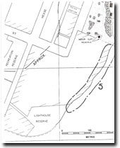
| Location | 952611. Short cliffed sector immediately east of the Queenscliff lighthouse (Shortlands Bluff). | 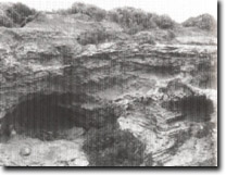 Site 5, Calcrete and calcarenite at Shortlands Bluff |
Access | From Ocean View Lookout carpark. | |
Ownership/Managing Authority | Commonwealth Land (Department of Transport, Lighthouse Reserve, and Defence Department, Fort Queenscliff College. | |
Site Description | The upper part of a calcarenite cliff is exposed behind a sector of masonry wall. The lower part of the section is firm, bedded calcarenite but the upper 3 m is complex with thick kunkar development, calcrete breccia, concretions and a buried soil. The section is overlain by unconsolidated dunes sands covering a shell midden. A shallow cave is developing in the softened sandstone below the kunkar horizon. In contrast to the Point Lonsdale, Lighthouse site (Site 2) the shore platform here is sand covered and not well exposed. | |
Significance | Local. The main features of significance are in the upper parts of the section. Although not as accessible, complex or continuous as the section at Point Lonsdale this site illustrates the similarities to the calcareous formations exposed there. It is the most accessible calcarenite section exposed at Queenscliff. | |
Management Considerations | Class 2. Occasional clearing of rubbish and trimming of overhanging vegetation is the main maintenance requirement. If the existing seawall is kept in repair, there would be little need for further cliff stabilization works to protect cliff top installations. | |
Site 5, Shortlands Bluff calcarenite beds

© State of Victoria (Agriculture Victoria) 1996 - .

This work, Victorian Resources Online, is licensed under a Creative Commons Attribution 4.0 licence. You are free to re-use the work under that licence, on the condition that you credit the State of Victoria (Agriculture Victoria) as author, indicate if changes were made and comply with the other licence terms.
The licence does not apply to ‘branding’ or some ‘images or photographs’ that may be owned by third parties. We ask you to seek prior approval to use images using the VRO feedback form. Access to higher quality images can also be provided on request.
This page was last updated on .