
28 Clifton Springs - Limestone Reef
|
This information has been developed from one or more of these publications:
|
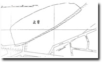
| Location | 863743. 400 m east of “The Dell” picnic area, Clifton Springs. The site occupies the intertidal zone west of the derelict baths at Clifton Springs. | 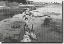 Site 28, Dipping limestone reef at Clifton Springs |
Access | Spring Street, Clifton Springs and road to “The Dell”. | |
Ownership/Managing Authority | Crown land (Port of Geelong Authority) below high water mark; private land above high water mark. | |
Site Description | This is one of the several sites where beds of hard, yellow fossiliferous limestone outcrop in the intertidal zone. The main bed, which is 50 to 60 cm thick, rises as a distinct ridge above the level of the shore platform, and generally dips northward at about 20o. In several places the bed is folded and there are numerous step faults with variable amounts of throw. The limestone is interbedded with blue and yellow clays which are richly fossiliferous. The outcrop near the Clifton Springs bath extends over 100 m and dips steeply northward. It is folded into a northerly pitching anticline and is cut by a fault with a displacement of 2 m. | |
Significance | Regional. The limestone reef has been the subject of several geological studies. It is an unusually hard material when it outcrops on the shore platform and is softer and less prominent in cliff section exposures. The faulting and folding displayed in this outcrop is unusual in Tertiary strata in Victoria. | |
Management Considerations | Class 1. No coastal reclamation or construction work should take place at the site. As the major features of interest occur in the intertidal zone, it is important that no dredging, filling, trenching or outfall pipes be put across this area. The limestone reef should be left intact. The gaps that occur due to faulting should not be used as routes for boat ramps or other seaward projecting structures. | |
References | Hall, T.S. & Pritchard G.B. (1894) Coulson, A. (1938) Ladd, P.G. (1971) | |
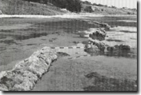 Site 28, Dipping, faulted limestone reef at Clifton Springs |

© State of Victoria (Agriculture Victoria) 1996 - 2025.

This work, Victorian Resources Online, is licensed under a Creative Commons Attribution 4.0 licence. You are free to re-use the work under that licence, on the condition that you credit the State of Victoria (Agriculture Victoria) as author, indicate if changes were made and comply with the other licence terms.
The licence does not apply to ‘branding’ or some ‘images or photographs’ that may be owned by third parties. We ask you to seek prior approval to use images using the VRO feedback form. Access to higher quality images can also be provided on request.
This page was last updated on 23/11/2018.