
20 Portarlington Pier - Geological Section and Platform
|
This information has been developed from one or more of these publications:
|
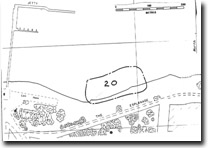
| Location | 944789. Coastal cliff from opposite Fisher St, approximately 400 m east of the Portarlington Jetty. | 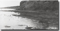 Site 20, Portarlington Pier |
Access | The Esplanade. | |
Ownership/Managing Authority | Crown land (Portarlington Foreshore Committee of Management and Department of Conservation, Forests and Lands). | |
Site Description | A degraded coastal cliff, partly covered by slump deposits, exposes Older Volcanics basalt and tuff and overlying sediments. The volcanics are best exposed nearer to the Portarlington Jetty where they form a wide, smooth gently sloping shore platform with variable gravel cover. In the platform, the basalts have a regular joint system which in places is infilled with secondary calcite plates. The cliff sections are higher than at Steeles Rock (Site 19) but slumping has obscured most of the significant exposures and makes access and study of the sections difficult. | |
Significance | Regional. Although the geological sections are of the same materials to those at Steeles Rock, the degraded state of the high cliffs reduces the significance of the exposures and contacts. The display of joint infilling in the basalts is of particular interest and the shore platform is a clear example of a broad, horizontal platform segment developed in weathered Older Volcanics. | |
Management Considerations | Class 2. The best exposure of the infilled joints is at the base of the cliff and the inner parts of the shore platform. It would be preferable not to build protective structures or beaches over this sector but to leave the outcrops exposed. | |
References | Jutson, J.T. & Coulson, A. (1937, 1940) Hills, E.S. (1938) | |
Site 20, Portarlington Pier

© State of Victoria (Agriculture Victoria) 1996 - .

This work, Victorian Resources Online, is licensed under a Creative Commons Attribution 4.0 licence. You are free to re-use the work under that licence, on the condition that you credit the State of Victoria (Agriculture Victoria) as author, indicate if changes were made and comply with the other licence terms.
The licence does not apply to ‘branding’ or some ‘images or photographs’ that may be owned by third parties. We ask you to seek prior approval to use images using the VRO feedback form. Access to higher quality images can also be provided on request.
This page was last updated on .