
9 Swan Bay - Tidal Flat
|
This information has been developed from one or more of these publications:
|
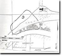
| Location | 940616. Coastline and bluff 100 m south of the Swan Bay Boat Club. | |
| Access | Off Nankervis Pde, Queenscliff, north of Queenscliff High School | |
| Ownership/Managing Authority | Crown Land (Borough of Queenscliff and Department of Conservation Forests and Lands). | |
| Site Description | The shoreline is muddy with fine sand and shell fragments on the surface. There is a variable cover of Xostera (Eel grass) on the tidal flat. To the east of the railway line is a calcarenite bluff. By digging a shallow pit into the mudflat, the site can be used to demonstrate the sedimentary characteristics of a low energy depositional environment where shells and fine sediments have been oxidised and leached by fluctuating water tables. The bluff indicates a period of higher energy wave environments. | |
Significance | Local. The site is a good and readily accessible example of a low energy, fine-grained, shell rich depositional environment. It contrasts with the higher energy sandy coast on the eastern side of the Queenscliff isthmus. | |
Management Considerations | Class 1. Reclamation, dredging, filling or shell excavation would destroy the nature of the site. Both the intertidal area and the calcarenite bluff need to be preserved without extensive modification. | |

© State of Victoria (Agriculture Victoria) 1996 - .

This work, Victorian Resources Online, is licensed under a Creative Commons Attribution 4.0 licence. You are free to re-use the work under that licence, on the condition that you credit the State of Victoria (Agriculture Victoria) as author, indicate if changes were made and comply with the other licence terms.
The licence does not apply to ‘branding’ or some ‘images or photographs’ that may be owned by third parties. We ask you to seek prior approval to use images using the VRO feedback form. Access to higher quality images can also be provided on request.
This page was last updated on .