
22 Point Richards South - Lobate Foreland
|
This information has been developed from one or more of these publications:
|
| Location | 910787. South of Ramblers Road, 2 km southwest of Point Richards. | 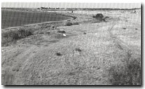 Site 22, Point Richards South terrace and foreland |
| Access | Rambler Road or Spray Farm Lane. | |
| Ownership/Managing Authority | Mostly private land, with some Crown land (vested in Port of Geelong Authority) | |
Site Description | Between Ramblers Road and Spray Farm Lane, in front of the bluff south and southwest of Point Richards, is a broad terrace of clay overlain by coarse beach sand with shells. The sequence is capped with a thin sheet of fine (possibly wind-blown) sand similar to that in the upper ridges of the Point Richards foreland (Site 21). At the southern end of Ramblers Road, the terrace is lobate in plan at the coast, with a complex of ridges and lagoons that resemble a formerly prograded foreland now deprived of sand supply. The form of the coast here suggests that sand drift at some time has been predominantly towards the northeast, which contrasts with the westerly drift of the Point Richards area today. | |
Significance | Regional. This site displays a variety of coastal depositional features of great interest in determining the Late Holocene sedimentary history of Port Phillip Bay. The site is of interest for the relict coastal ridges, lagoons and the terrace. | |
Management Considerations | Class 2. Minimal disturbance of the outer ridges and lagoons is needed to allow interpretation of the recent sedimentary history and geomorphological development of the site. As much of the ridge and lagoon system should be left intact as is consistent with low intensity use of the site. | |
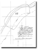
Site 22 Point Richards South (inset shows location of main map)

© State of Victoria (Agriculture Victoria) 1996 - .

This work, Victorian Resources Online, is licensed under a Creative Commons Attribution 4.0 licence. You are free to re-use the work under that licence, on the condition that you credit the State of Victoria (Agriculture Victoria) as author, indicate if changes were made and comply with the other licence terms.
The licence does not apply to ‘branding’ or some ‘images or photographs’ that may be owned by third parties. We ask you to seek prior approval to use images using the VRO feedback form. Access to higher quality images can also be provided on request.
This page was last updated on .