
Soil/Landform Mapping St Arnaud - St Arnaud Mapsheet
To view the information PDF requires the use of a PDF reader. This can be installed for free from the Adobe website (external link).
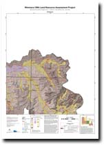 | Map of St Arnaud - (T7254) (Adobe 1.1 Mb) | Landform Units Map Unit descriptive names (Adobe pdf 109 Kb) |
| Soil/Landform Units | |||
| Ararat Hills | Concongella Hills | Drung Alluvial Plains | Elmhurst Footslopes |
| Glenorchy 1 | Glenorchy 2 | Howard Creek 1 | Howard Creek 2 |
| Howard Creek 3 | Joel South Hills | Kanya Hills | Landsborough 2 |
| Landsborough 3 | Langi Ghiran Ranges | Langi Slopes 2 | Navarre 1 |
| Navarre 2 | Navarre 3 | Pyrenees Mountains | Rhymney Hills |
| Six-Seven Mile Creeks | Sugarloaf Granitic Hills | Surridge 2 | Wattle Creek Covered Plain |
| Soil Groups | |
| 1 | 10 |
| Soil Pits | |
| LP 82 LP 83 DOAGW 32 | LP 80 DOAGW 2 DOAGW 17 |
| Geomorphic Units | ||||||
| 2.1.1 | 2.1.2 | 2.1.3 | 2.1.4 | 2.1.5 | 2.1.6 | 2.1.7 |
| 2.2.1 | 2.2.2 | 2.2.3 | 2.3.1 | 2.3.2 | 4.1.1 | 4.1.2 |
| 4.2.1 | 4.2.2 | 4.2.3 | 4.3 | 5.1.3 | 5.1.5 | 5.2.1 |
| 5.2.2 | 5.3.3 | 5.4 | 5.5.1 | 5.5.2 | 5.5.3 | 5.6 |
| 6.2.1 | ||||||
© State of Victoria (Agriculture Victoria) 1996 - .

This work, Victorian Resources Online, is licensed under a Creative Commons Attribution 4.0 licence. You are free to re-use the work under that licence, on the condition that you credit the State of Victoria (Agriculture Victoria) as author, indicate if changes were made and comply with the other licence terms.
The licence does not apply to ‘branding’ or some ‘images or photographs’ that may be owned by third parties. We ask you to seek prior approval to use images using the VRO feedback form. Access to higher quality images can also be provided on request.
This page was last updated on .