
4.2.3 Lakes and basins with lunettes (Lake Hindmarsh, Lake Albacutya)
|
This land unit occurs predominantly within the Older alluvial plains complex (unit 4.2) as depressions of various sizes and complexity. The larger occurrences are in the north as part of the Lowan Salt Valley in the form of Lakes Hindmarsh and Albacutya with the Wimmera River being the main stream. Smaller examples occur further upstream, east of Horsham as part of the broader alluvial Wimmera River system such as Green, Pine and Taylors lakes. A number of more isolated occurrences are on the broader plains and plain/ridge landscape complexes west and south of the Wimmera River. | 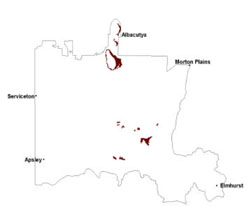 |
These units have formed in depressions due to a variety of processes such realignment of drainage lines, scouring by drainage lines in variably resistant material, differential deposition and tectonic movement. The larger lakes with multiple lunettes indicate multiple phases of deflation and aggradation, implying they are older than the recent deposition. Deflation of lake bed material by desiccation of salty deposits in arid environments has resulted in lunette development in the direction of the prevailing wind.
Drainage of these features as well as their formation is the result of the amount of water passed through as well as their ability to seal or leak. There is very limited immediate catchment area as well as low precipitation in the current climate.
Organic rich fine sediments tend to dominate the depressions on which cracking clay soils (Vertosols and Sodosols, often self-mulching) have evolved. Fine sands occur around the rim (Sodosols, Tenosols) such as at Lake Hindmarsh. Lunettes often have a deep fine calcareous material regolith with calcareous soils (Calcarosols) which are often highly sodic as well.
Remnant vegetation is comprised mostly of woodland vegetation such as Lignum Swampy Woodland, Plains Woodland, Lunette Woodland, Riverine Chenopod Woodland, Creekline Sedgy Woodland and Low Rises Woodland. At Lake Hindmarsh and Lake Albacutya, Sandstone Ridge Shrubland, Red Swale Mallee, Lowan Sands Mallee, Parilla Mallee, Heathy Mallee and Dunefield Heathland are found. Brackish Lake Mosaic, Red Gum Wetland and Plains Savannah are associated with lakes and back plains. Salt tolerant grasses and forbes occur around lakes and swamps with a succession to trees on the rim material and the lunettes.
Waterlogging is the major issue, but fluctuating water levels and water quality also have some impact. Scalded (saline) surfaces are susceptible to wind erosion.
Fluctuating water levels and water quality are issues that may wax and wane in importance for land management whether it be for production or natural resource management.
Soil-landform unit | Unit description | Area (km2) |
| Hindmarsh-Albacutya lunettes | Lunette | 132 |
| Horsham lake and lunettes | Lake and lunette | 11 |
| Horsham lake-lunette cluster | Lake-lunette cluster | 76 |
| Werrap lake-lunettes | Lake-lunette complex | 2 |
Figure 10 Active scald erosion exposing sediments of the Lake Albacutya lunette (note the presence of a second lunette in the foreground)
© State of Victoria (Agriculture Victoria) 1996 - .

This work, Victorian Resources Online, is licensed under a Creative Commons Attribution 4.0 licence. You are free to re-use the work under that licence, on the condition that you credit the State of Victoria (Agriculture Victoria) as author, indicate if changes were made and comply with the other licence terms.
The licence does not apply to ‘branding’ or some ‘images or photographs’ that may be owned by third parties. We ask you to seek prior approval to use images using the VRO feedback form. Access to higher quality images can also be provided on request.
This page was last updated on .