
5.3.3 Salt lake depression (Douglas Depression)
|
This third tier sub-division is made up of one large continuous unit located in Western Victoria; one of the most southerly occurrences of the Dunefields and Plains geomorphological Division (Tier 1; 5). | 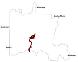 |
The Douglas Depression is an area of saline discharge, as evidenced by the lake systems (often with lunette formations) and varying periods of water present, and is likely to be structually controlled. The depth and age of regolithic material in the depression is not well known. Regolith is typically alluvial sourced including significant deposits of clay and gypsum that are strongly associated with salinas and lunettes during arid dune-building phases (Bowler 1976; Hill & Bowler 1995). It should be noted that similar formations of stranded beach ridges occur on both sides of the Douglas Depression (the ridges were formed approximately 4 Ma). There is an incursion of Lowan Sand across the depression to the north of Douglas, somewhat masking the depression and the older ridge material. There is speculation, given the sharp flow direction change of the Wimmera River that the depression is a paleochannel of a south to north flowing stream or indeed a north-south stream before the uplift (doming) of the Dundas Tableland (unit 2.3); some form of river capture has taken place. Another theory is that this was an outlet for a former lake (Lake Bungunnia) as the inland sea of the Murray Basin retreated.
The depression is an extension of what is known as the Lowan Salt Valley. The climate becomes milder and moister south of the Little Desert thus the calcareous soils and mallee vegetation start to disappear southwards; the Lowan Salt Valley is the most southerly incursion of mallee type environment into the riverine environment further south.
The Douglas Depression has a range of soils from calcareous earths (Calcarosols) in the north to sodic and saline texture contrast and cracking clay soils to the south and amongst the lakes and swamps. These texture contrast soils and heavy variants are prone to seasonal waterlogging with very poor site drainage. While sandy soils (Kandosols) can occur as aeolian sand spill overs from the western plains, most soils are extremely sodic at depth and often saline when in association with salinas.
Vegetation communities include a number of woodland and wetland associations including Heathy Woodland, Plains Woodland, Low Rises Woodland, Riverine Chenopod Woodland, Seasonally Inundated Shrubby Woodland, Lunette Woodland, Plains Woodland and Salt Paperbark Woodland. Other vegetation communities include Aquatic Herbland, Plains Savannah, Ridged Plains Mallee and Dunefield Heathland. The depressions are also associated with a number of vegetation communities that grow in saline conditions including Lignum Swampy Woodland, Brackish Sedgeland, Red Gum Wetland, Plains Savannah, Brackish Wetland, Inland Saltmarsh, Samphire Shrubland and Saline Lake Mosaic, as well as permanent and semi-permanent saline wetlands.
Soil-landform unit | Unit description | Area (km2) |
| Douglas lake and lunettes | Lake and lunette | 58 |
| Natimuk-Douglas valley | Shallow valley | 293 |
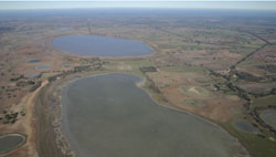
Figure 16 Lakes and lunettes (White Lake and Centre Lake) at Douglas
© State of Victoria (Agriculture Victoria) 1996 - .

This work, Victorian Resources Online, is licensed under a Creative Commons Attribution 4.0 licence. You are free to re-use the work under that licence, on the condition that you credit the State of Victoria (Agriculture Victoria) as author, indicate if changes were made and comply with the other licence terms.
The licence does not apply to ‘branding’ or some ‘images or photographs’ that may be owned by third parties. We ask you to seek prior approval to use images using the VRO feedback form. Access to higher quality images can also be provided on request.
This page was last updated on .