
Soil/Landform Unit - Wattle Creek covered plain
Landform Unit Description
Page top
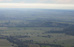 Alluvial plains in the distance, east of Navarre |
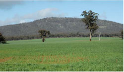
0.31% of CMA region Flats and gentle slopes in the upper Wimmera River catchment around Navarre are part of the Dissected Western Uplands sequence of terraces and floodplains (2.1.7). These flats, gentle slopes and drainage lines are fed from the Navarre to the north and the Pyrenees Ranges to the east and lead into the Wimmera River alluvial complex as it moves out of the uplands onto the older alluvial plains. Flats are dominant with gentle slopes, moderate to gentle upper footslopes, drainage lines and terrace flats also. Soils are predominantly red texture contrast soils (Chromosols), with sodic brown, yellow and grey texture contrast soils (Sodosols) particularly in the poorer drained positions. Sheet, rill and gully erosion are land degradation issues given the texture contrast nature of the soil, especially where the subsoil is sodic and exposed. This unit is used for grazing (sheep, beef cattle), with occasional dryland cropping and viticulture. Vegetation communities recorded include Heathy Dry Forest, Creekline Grassy Woodland, Plains Woodland, Riparian Woodland, Alluvial Terraces Herb-rich Woodland and Swampy Riparian Woodland. |  |
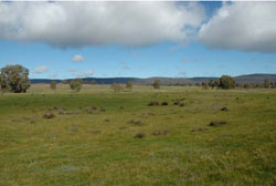 Gentle slopes near Moonambel looking towards Pyrenees Ranges |  |
 |  Crops on gentle slopes beneath Blue Mount |
Component | 1 | 2 | 3 | 4 | 5 |
Proportion of soil-landform unit | 10% | 30% | 45% | 5% | 10% |
| CLIMATE Rainfall (mm) | Annual: 575 | ||||
| Temperature (oC) | Minimum 8, Maximum 20 | ||||
| Precipitation less than potential evapotranspiration | October–April | ||||
| GEOLOGY Age and lithology | Quaternary fluvial silt, sand & minor gravel (Shepparton Fm); Cambrian marine sandstone, siltstone & biotite schist (St Arnaud Group) | ||||
| Geomorphology | |||||
| LANDUSE | Uncleared areas: Water supply; nature conservation Cleared areas: Sheep and beef cattle grazing; dryland cropping; viticulture | ||||
| TOPOGRAPHY Landscape | Alluvial plains and valleys | ||||
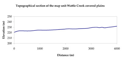
| Elevation range (m) | 197–365 | ||||
| Local relief (m) | 5–7 | ||||
| Drainage pattern | Dendritic | ||||
| Drainage density (km/km2) | 1.9 | ||||
| Landform | Footslopes | Alluvial plains | |||
| Landform element | Moderate to gentle upper footslopes | Gentle slopes | Flats | Terrace flat | Drainage lines |
| Slope and range (%) | 8 (5-20) | 4 (2-10) | 1 (0-2) | 2 (0-7) | 2 (0-5) |
| Slope shape | Convex | Straight | Straight | Straight | Concave |
| NATIVE VEGETATION Ecological Vegetation Class | Plains Woodland (38.9%), Creekline Grassy Woodland (18.5%), Grassy Woodland/Alluvial Terraces Herb-rich Woodland Mosaic (18.5%), Riparian Woodland (7.4%), Other (14.8%) | ||||
| SOIL Parent material | In situ marine sandstone, siltstone and biotite schist, fluvial gravel, sand and silt | Fluvial gravel, sand and silt | Fluvial gravel, sand and silt | Fluvial gravel, sand and silt | Alluvial gravel, sand and silt |
| Description (Corangamite Soil Group) | Red texture contrast soils (10) | Sodic brown, yellow and grey texture contrast soils (12) | |||
| Soil type sites | DOAGW17, DOAGW2, LP80 | ||||
| Surface texture | Sandy clay loam | Loamy sand | Loam, fine sandy (heavy) | Sandy loam | Loam, fine sandy (heavy) |
| Permeability | Moderate | Moderate | Moderate - slow | Moderate - high | Slow |
| Depth (m) | > 2 | > 2 | > 2 | > 2 | > 2 |
| LAND CHARACTERISTICS, POTENTIAL AND LIMITATIONS Critical land features, processes, forms | Hardsetting and soft surfaces susceptible to sheet and rill erosion even on gentle slope due to impeding layer (clay or hardpan). Subsurface soil and upper subsoil susceptible to compaction, and also gully erosion where sodic subsoils are exposed. Topsoil may be susceptible to acidification. | Lighter surface susceptible to sheet and rill erosion and compaction. Subsoil susceptible to gully erosion where exposed. Lighter variants are well drained. | Lighter surface susceptible to sheet and rill erosion and compaction, especially with low organic matter. Subsoil susceptible to rill and gully erosion where sodic and exposed. Lighter variants are well drained. Upper soil susceptible to acidification. | Light soil surface susceptible to sheet and rill erosion and compaction. Subsoil susceptible to rill and gully erosion where sodic. Lighter soil variants are well drainage. Upper soil susceptible to acidification. | Lighter surface susceptible to sheet and rill erosion and compaction, especially with low organic matter. Subsoil susceptible to rill and gully erosion where sodic, deeper and sloping terrain. Lighter variants are well drained. Upper soil susceptible to acidification. |
© State of Victoria (Agriculture Victoria) 1996 - .

This work, Victorian Resources Online, is licensed under a Creative Commons Attribution 4.0 licence. You are free to re-use the work under that licence, on the condition that you credit the State of Victoria (Agriculture Victoria) as author, indicate if changes were made and comply with the other licence terms.
The licence does not apply to ‘branding’ or some ‘images or photographs’ that may be owned by third parties. We ask you to seek prior approval to use images using the VRO feedback form. Access to higher quality images can also be provided on request.
This page was last updated on .