
5.5.3 Prominent ridges with eroded ferruginozed northern spurs (south of the Lower Norton Wimmera Bridge - Darragan)
|
This unique unit of nearly 9500 ha occurs in the WCMA region of western Victoria. It lies south of the original small Quantong Irrigation Settlement and the Wimmera River. It is immediately south of the road junction at Lower Norton, east of the East Natimuk-Noradjuha Road and west of Norton Creek. Two roads traverse the unit, the Lower Norton- Noradjuha Road and the more easterly Lower Norton- Toolondo Road. This latter road crosses the centre of the unit for about 7 km. |  |
The unit occurs mainly between the 130 m and 150 m contours. The elongated rolling rises comprise a sequence of landform elements reflecting truncation of the ridges by the Wimmera River in the north, and lateral erosion of the ridges which is less effective to the south where these ridges become more subdued within the landscape towards the Dundas Tableland. Relative relief is about 10–15 m from the old plain surface (ridge crests) to the Wimmera River floodplain Side slopes of the spurs are gently inclined (undulating) averaging 2-5%, with level to very gentle flats typical of the swales. Ridges slope along the north-south axis of their crests average about 1%. Narrow valleys between the spurs contain at least five unnamed unidirectional stream channels, which under flood conditions may flow north across the floodplain to join the Wimmera River. To the south the land surfaces continue to rise to above the 160 m contour within the adjacent Horsham South flat plains.
Deeply weathered texture contrast soils are dominant across the unit. Sodosols occur on the crests and slopes of the ridges with red and brown Sodosols on crests and red Sodosols on slopes. Sodosols with cemented (ferruginised) subsurface horizons and mottled subsoils occur on inter-ridge corridors.
Ironstone gravels in varying amounts are commonly present both as a surface pavement throughout soil profiles. Varying amounts of soft and hard carbonate segregations are often present in subsoils with cracking clays confined to lower drainage depressions and flats. Bleached Tenosols occur on terrace landform elements along inter-ridge corridors.
Dominant woodland remnant vegetation includes Heathy Woodland, Riverine Chenopod Woodland, Grassy Woodland, Creekline Sedgy Woodland, Plains Woodland and Shallow Sands Woodland with Grey Box and Yellow Gum found along narrow valley floors. Sandstone Ridge Shrubland is also found along ridges and rises in the landscape.
Sheet and rill erosion provide source material for the Wimmera River floodplain and terraces. Soils are prone to compaction due to hardsetting surfaces that benefit from organic matter contributions to improve soil structure. Land use is variable between dryland cereal cropping, sheep and cattle grazing and occasional intensive industries (e.g. viticulture).
Soil-landform unit | Unit description | Area (km2) |
| Darragan rolling rises | Rolling rises | 92 |
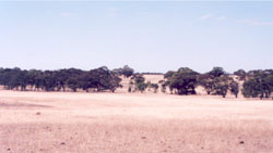
Figure 19 View is to the north-east across a corridor to a ridge about 0.8 km in the distance
© State of Victoria (Agriculture Victoria) 1996 - .

This work, Victorian Resources Online, is licensed under a Creative Commons Attribution 4.0 licence. You are free to re-use the work under that licence, on the condition that you credit the State of Victoria (Agriculture Victoria) as author, indicate if changes were made and comply with the other licence terms.
The licence does not apply to ‘branding’ or some ‘images or photographs’ that may be owned by third parties. We ask you to seek prior approval to use images using the VRO feedback form. Access to higher quality images can also be provided on request.
This page was last updated on .