
5.5.1 Prominent ridge tops with remnant aeolian sands and orientated swales with lakes and lunettes (north of Little Desert - Diapur, Kiata)
|
This unit is located in western Victoria, clearly bounded by the Little Desert to the north and the low plateau (Dundas Tableland) to the south. The South Australian border is the artificial western boundary and the Wimmera River Valley (Lowan Salt Valley) and the Douglas Depression comprise the eastern boundary. | 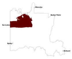 |
These plains of Quaternary lacustrine and aeolian sediments is part of a NNW/SSE orientated terrain surrounded by associated rises/ridges and other ridge/depression landscapes. Drainage is strongly aligned to the terrain with little surface expression apart from local depressions, including swamps and lakes. Sandy surfaced sodic texture contrast soils (Sodosols) and sandy soils (Rudosols and Tenosols) are generally acidic and occur on the Parilla Sand exposures and the Lowan Sand terrain, while sodic (Sodosols)and non-sodic texture (Chromosols) contrast soils occur on the smaller ridges and lower. Grey and black cracking clay soils (Vertosols) formed on lagoonal deposits dominate the swales and valley floors.
Woodland and mallee vegetation communities such as Low Rises Woodland, Heathy Mallee, Red Swale Mallee, Ridged Plains Mallee, Plains Woodland, Parilla Mallee and Shallow Sands Woodland dominate remnant vegetation on sandy rises and dunes. Other vegetation communities recorded include Plains Savannah, Plains Grassland and Sandstone Ridge Shrubland. The main vegetation communities of the former stranded beach ridges include Shallow Sands Woodland, Sandstone Ridge Shrubland, Ridged Plains Mallee, Parilla Mallee and Low Rises Woodland. Smaller extents of Heathy Woodland, Lowan Sands Mallee, Dunefield Heathland, Plains Woodland and Plains Savannah have also been recorded. Plains Savannah and Ridged Plains Mallee are the most expansive remnant vegetation communities found mostly on clay soils and plains. Areas of other vegetation communities such as Lignum Swampy Woodland, Plains Woodland, Sandstone Ridge Shrubland, Shallow Sands Woodland, Parilla Mallee, Low Rises Woodland and Heathy Mallee are also found. Lignum Swampy Woodland, Plains Woodland, Red Gum Wetland and Seasonally Inundated Shrubby Woodland are found in wetter areas of the landscape.
Sheet erosion is relevant to any sloping terrain with water repellancy as an associated issue in this unit. Wind and gully erosion is a land degradation issue particularly relevant to the larger ridges. Water repellency is an issue on the sandy surfaced soils with some organic matter, particularly where surface soil horizons are shallow. Waterlogging may be an issue on the valley floors depending on rainfall events, as rainfall increases southward.
Soil-landform unit | Unit description | Area (km2) |
| Broughton plains | Gently undulating plain | 69 |
| Diapur ridge | Undulating stranded beach ridge | 648 |
| Kiata rises | Gently undulating rises | 519 |
| Lillimur South clay plains | Self-mulching clay plains | 127 |
| Lorquon undulating plains | Gently undulating plain | 784 |
| Nhill lake and lunettes | Lake | 73 |
| Perenna undulating sand plains and rises | Gently undulating sand plains | 179 |
| Servicetown North limestone rises | Limestone rises | 5 |
| Woorak clay plains | Grey clay plain | 539 |
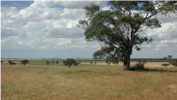
Figure 17 Former stranded beach ridges (rises) with swales orientated NNW/SSE near Boyeo
© State of Victoria (Agriculture Victoria) 1996 - .

This work, Victorian Resources Online, is licensed under a Creative Commons Attribution 4.0 licence. You are free to re-use the work under that licence, on the condition that you credit the State of Victoria (Agriculture Victoria) as author, indicate if changes were made and comply with the other licence terms.
The licence does not apply to ‘branding’ or some ‘images or photographs’ that may be owned by third parties. We ask you to seek prior approval to use images using the VRO feedback form. Access to higher quality images can also be provided on request.
This page was last updated on .