
2.1.5 Plateaux and rises of residual Cainozoic landscapes (Great Western, Glenorchy)
|
Widespread deposition of sands and gravels are preserved as fringing sheets of capping material across Palaeozoic sediments and granitic terrains of the upper Wimmera catchment. They are significant due to their preservation of underlying bedrock as resistant ferricrete and silcrete. Examples include the undulating rises near Great Western and gentle to undulating plains from Deep Lead to Glenorchy and Mokepilly. | 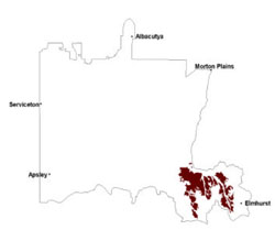 |
The Great Western Formation (or White Hill equivalents) has been found between 220 and 290 mAHD in the upper Wimmera catchment (Hocking 1997). Laying above current alluvial deposits, the gravels are the erosional remnants of prominent fluvial systems that were active through much of the Western Uplands. Deposit thickness varies from less than 1 m to in excess of 15 m on footslopes/terraces/rises of the Wimmera River valley and other terrain (e.g. Rocky Point undulating rises). Size and compositional sorting of the gravels is poor (Cayley & MacDonald 1995) with quartz reef derived clasts located within a matrix of fine to very coarse sand, minor silt and clay.
Deposition of these sediments is often followed by deep weathering including ferruginisation/silicification, and kaolinisation of underlying Palaeozoic bedrock (Taylor & Joyce 1996). This can be observed today as inverted landscapes through preferential denudation (e.g. deep lead development).Later activity in the Neogene saw the retreat of the sea from the Murray Darling Basin and deposition of fine to coarse-grained quartz sands as sand ridges and beach relicts (shoreline dunes). The Parilla Sand deposits form subparallel ridges that are often ferruginised and are more commonly expressed in the Millicent Coast Basin area of the WCMA region.
Developed on these sediments are a suite of texture contrast soils (yellow, brown, red; sodic and nonsodic) and red gradational or uniform soils.
The yellow and brown texture contrast soils (Sodosols and Chromosols) are often associated with Kandosols where soils are slightly acidic at the surface but become neutral or alkaline at depth. Brown sandy loams overlie conspicuously bleached massive loamy sands with variable amounts of coarse quartz fragments. Mottled yellowish brown medium clays provide a sharp texture change from above material. The brown to red texture contrast soils are similar with pronounced red subsoil mottling and ferruginous nodules (buckshot) common in the bleached subsurface horizon.
Red gradational or uniform soils are acidic profiles with brown sandy loam surfaces containing variable amounts of coarse quartz fragments. This gradually changes to yellowish red sandy clay that also has quartz gravels. This soil has a greater capacity for water infiltration and drainage than the texture contrast variants.
Undulating landscapes dominated by sandy deposits have main vegetation communities including Heathy Woodland to Box Ironbark Forest and Plains Sedgy Woodland. Other vegetation communities present include Plains Grassy Woodland, Grassy Woodland, Grassy Woodland/Heathy Woodland Mosaic, Plains Woodland and Drainage-line Woodland. Landscapes further up Mount William Creek (including the plains at Mokepilly and undulating rises at Bellellen) have Heathy Woodland and Plains Grassy Woodland also with variants including Damp Sands Herb-rich Woodland, Red Gum Wetland, Heathy Dry Forest, Sedge-rich Woodland, Shallow Freshwater Marsh, Shallow Sands Woodland and
Lateritic Woodland.
Landscapes dominated by gravels intermixed with sand, silt and clays include the vegetation communities Heathy Dry Forest, Grassy Dry Forest, Heathy Woodland, Plains Grassy Woodland, Alluvial Terraces Herb-rich Woodland, Grassy Woodland, Plains Woodland and Creekline Grassy Woodland.
The deeply weathered nature of these landscapes represents groundwater systems that are very slowly permeable generally owing to significant kaolin deposits with high salt stores. Saline discharge often occurs as localised events or subartesian in lower landscape positions. Gully and tunnel erosion are prominent on moderate to gentle slopes. It is often a combatant or by-product of saline discharge mechanisms that lead to exposure of vulnerable sodic subsoils and ultimately erosion.
Soil-landform unit | Unit description | Area (km2) |
| Bellellen undulating rises | Undulating low hills and rises, footslopes and foothills | 139 |
| Glenorchy rises | Dissected plains | 249 |
| Great Western rises | Foothills and footslopes | 412 |
| Howard Creek plains | Dissected plains | 32 |
| Mokepilly undulating plains | Undulating plain | 33 |
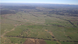
Figure 6 Undulating plains and rises with creeks and erosion scars near Salt Creek
© State of Victoria (Agriculture Victoria) 1996 - .

This work, Victorian Resources Online, is licensed under a Creative Commons Attribution 4.0 licence. You are free to re-use the work under that licence, on the condition that you credit the State of Victoria (Agriculture Victoria) as author, indicate if changes were made and comply with the other licence terms.
The licence does not apply to ‘branding’ or some ‘images or photographs’ that may be owned by third parties. We ask you to seek prior approval to use images using the VRO feedback form. Access to higher quality images can also be provided on request.
This page was last updated on .