
Soil/Landform Unit - Sugarloaf granitic hills
Landform Unit Description
Page top
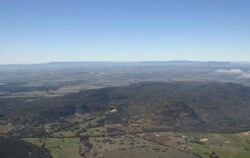 North-western slopes of the Black Range near Stawell |
0.49% of CMA region The eastern Black Range, south-west of Stawell (Sugarloaf granitic hills has been used to avoid confusion with the western Black Range) is part of the Dissected Western Uplands. Occupying the western end of the Western Dissected Uplands with a vale separating it from the Grampians Ranges, the granite hills are surrounded by outwash slopes and lower metasedimentary terrain of rises and plains. Steep slopes and crests (with rock outcrop) are dominant with colluvial slopes surrounding the hilly terrain. Drainage depressions and drainage lines are present with a radial drainage system extending to the Mt William Creek alluvial system. Soils are extremely shallow sandy soils (Rudosols) on steep slopes and areas of outcrop with yellow texture contrast soils that are sodic (Sodosols) on the lower slopes. Sheet and rill erosion are the major land degradation susceptibilities for this unit with wind erosion of light topsoils possible where exposed. This unit is used for grazing (sheep, beef cattle), occasional dryland cropping, quarrying (sand and gravel) and a water supply function in some areas. A variety of remnant vegetation communities have been recorded including woodland and scrub. | 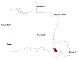 |
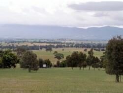 Looking west towards Mount William Creek from the Black Range | 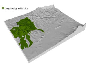 |
 | 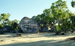 Sister Rocks on the Western Highway near Stawell |
Component | 1 | 2 | 3 | 4 |
Proportion of soil-landform unit | 20% | 30% | 40% | 10% |
| CLIMATE Rainfall (mm) | Annual: 650 | |||
| Temperature (oC) | Minimum 8, Maximum 19 | |||
| Precipitation less than potential evapotranspiration | October–April | |||
| GEOLOGY Age and lithology | Neogene fluvial gravel, sand and silt; Cambrian marine sandstone, siltstone and shale (Glenthompson sandstone); Cambrian basalt, andesite, boninite, rhyolite, gabbro and lithics | |||
| Geomorphology | ||||
| LANDUSE | Uncleared areas: water supply; nature conservation; gravel and sand extraction Cleared areas: sheep and beef cattle grazing; water supply; gravel and sand extraction | |||
| TOPOGRAPHY Landscape | Granite hills | |||
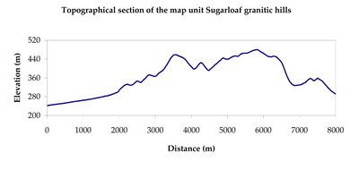
| Elevation range (m) | 196–286 | |||
| Local relief (m) | 90 | |||
| Drainage pattern | Dendritic | |||
| Drainage density (km/km2) | 1.7 | |||
| Landform | Colluvial footslopes | Hills | ||
| Landform element | Creek/drainage depression | Colluvial footslope | Steep hillslope/crest | Drainage line |
| Slope and range (%) | 2 (0-3) | 5 (3-10) | 30 (5-65) | 3 (2-5) |
| Slope shape | Concave | Concave | Convex | Concave |
| NATIVE VEGETATION Ecological Vegetation Class | Plains Grassy Woodland (36.7%), Hills Herb-rich Woodland (13.5%), Heathy Woodland (10.9%), Alluvial Terraces Herb-rich Woodland (10.5%), Other (27.9%) | |||
| SOIL Parent material | Fluvial gravel, sand and silt | Colluvial gravel, sand and silt, in situ intrusive granite | In situ intrusive granite | In situ intrusive granite, fluvial gravel, sand and silt |
| Description (Corangamite Soil Group) | Sodic yellow texture contrast soils (4) | Sodic yellow texture contrast soils (4) | Yellow texture contrast soils (3) | |
| Soil type sites | GW28, GW30 | GW28, GW30 | ||
| Surface texture | Clayey coarse sand to sandy clay loam | Clayey coarse sand | Silty loam (sandy) | Sandy clay loam |
| Permeability | Very slow | Slow | Moderate to high | Slow |
| Depth (m) | > 2 | > 2 | < 0.7 | 0.5-1.5 |
| LAND CHARACTERISTICS, POTENTIAL AND LIMITATIONS Critical land features, processes, forms | Sodic subsoil susceptible to gully erosion. Poor subsurface drainage, particularly on flats and depressions. Surface soils susceptible to acidification. | Light loose surface soils susceptible to wind, sheet and rill erosion in drier areas (including drier aspects). Sodic subsoil susceptible to gully erosion. Surface soils susceptible to acidification. | Light loose surface soils that may be susceptible to wind, sheet and rill erosion in drier areas (including drier aspects). Susceptible to acidification in wetter areas. | Sodic subsoil susceptible to gully erosion. Poor subsurface drainage, particularly on flats and depressions. Surface soils susceptible to acidification. |
© State of Victoria (Agriculture Victoria) 1996 - .

This work, Victorian Resources Online, is licensed under a Creative Commons Attribution 4.0 licence. You are free to re-use the work under that licence, on the condition that you credit the State of Victoria (Agriculture Victoria) as author, indicate if changes were made and comply with the other licence terms.
The licence does not apply to ‘branding’ or some ‘images or photographs’ that may be owned by third parties. We ask you to seek prior approval to use images using the VRO feedback form. Access to higher quality images can also be provided on request.
This page was last updated on .