
5.2.1 Parabolic dunes
|
Within the Little Desert and Big Desert the landscape has been fashioned into a complex array of undulating sand plains, east-west aligned dunes and jumbled dunes. The largest individual areas of parabolic dunefields occur in the Big Desert in three east-west swathes to the west of the linear depression containing the Wimmera River system. The swathes are some 10-20 km wide and up to 90 km long. These dunefields include a broad ridge running south-east from the Pinnaroo Block as well as stranded ridges and associated swales. The northernmost swale crosses the fringe of the regional depression to the east of the Sunset Strip. | 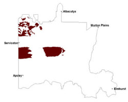 |
The major soils are Rudosols. Humus has accumulated at the surface except on unstable dune crests. Below the humus there are deep, loose, yellow sands over the whole landscape. In profiles examined to the south of Murrayville, coarse sand predominated and carbonates were confined to occasional flecks. The reaction was neutral in the top metre or so, but alkaline below this. Values for all plant nutrients examined were low (exchangeable metal cations, nitrogen and potassium). Lowan Sand is also known to be deficient in trace elements such as copper and zinc.
Vegetation across the three deserts varies with the large shift in climate. Average annual rainfall declines from 500 mm in the Little Desert to less than 300 mm in the Sunset Desert, and temperatures increase in the same direction. In the Big and Little deserts heathlands predominate with vegetation communities including a range of woodland, heathland and mallee vegetation. Prominent communities include Shallow Sands Woodland, Plains Woodland, Sandstone Ridge Shrubland, Heathy Mallee and Lowan Sands Mallee. Other vegetation communities include Dunefield Heathland, Low Rises Woodland, Plains Woodland, Parilla Mallee and Red Swale Mallee. Red Gum Wetland and Seasonally Inundated Shrubby Woodland have also been found in wetter areas of the landscape.
An abundance of species includes genera such as Banksia, Xanthorrhoea and Epacris. These species sometimes form an understorey to mallee eucalypts, particularly along sheltered slip faces, the stands being known as ‘mallee-heath’. In the Sunset Desert, aridity is too great for heath which is replaced by mallee scrub with a prominent understorey of tea-tree.
Soil-landform unit | Unit description | Area (km2) |
| Big Desert jumbled dunes | Sandplain with jumbled dunes | 478 |
| Diapur ridge | Beach ridge and dunes | 93 |
| Goroke plains and rises | Plains with prominent ridges | 118 |
| Kiata rises | Gently undulating rises | 19 |
| Little Desert linear dunes | Linear dunes | 22 |
| Little Desert parabolic dunes | Parabolic dunes | 1064 |
| Nhill lake and lunettes | Lake-lunette | 2 |
| Wail parabolic dunes | Parabolic dunes | 33 |
| Woorak clay plains | Grey clay plains | 18 |
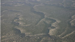
Figure 14 jumbled dunes of the Big Desert
© State of Victoria (Agriculture Victoria) 1996 - .

This work, Victorian Resources Online, is licensed under a Creative Commons Attribution 4.0 licence. You are free to re-use the work under that licence, on the condition that you credit the State of Victoria (Agriculture Victoria) as author, indicate if changes were made and comply with the other licence terms.
The licence does not apply to ‘branding’ or some ‘images or photographs’ that may be owned by third parties. We ask you to seek prior approval to use images using the VRO feedback form. Access to higher quality images can also be provided on request.
This page was last updated on .