
10. Red texture contrast soils/Dissected Uplands: Terraces and floodplains
|
This soil has developed on mainly Quaternary alluvial and colluvial unconsolidated material in the Western Uplands. This soil is often strongly acidic at the surface, tending to neutral at depth.
|  |
Soil Sites
Site code | Soil-landform unit | Component | ASC | FK | 1:100 000 mapsheet |
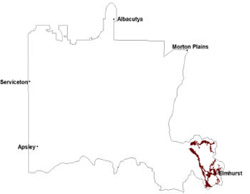
| DOAGW17 | Six-Seven Mile creeks | Plain | Bleached-Mottled, Mesotrophic, Red Chromosol | Dr2.62 | T7423 - Ararat |
| DOAGW2 | Six-Seven Mile creeks | Plain | Bleached, Mesotrophic, Red Chromosol | Dr2.42 | T7423 - Ararat |
| LP80 | Wattle Creek covered plain | Terrace | Bleached, Eutrophic, Red Chromosol | Dr2.22 | T7254 - St Arnaud |
© State of Victoria (Agriculture Victoria) 1996 - .

This work, Victorian Resources Online, is licensed under a Creative Commons Attribution 4.0 licence. You are free to re-use the work under that licence, on the condition that you credit the State of Victoria (Agriculture Victoria) as author, indicate if changes were made and comply with the other licence terms.
The licence does not apply to ‘branding’ or some ‘images or photographs’ that may be owned by third parties. We ask you to seek prior approval to use images using the VRO feedback form. Access to higher quality images can also be provided on request.
This page was last updated on .