
2.1.3 Ridges, escarpments, mountains on granitic Palaeozoic rock (Langi Ghiran, western Black Range - Mount Sugarloaf)
|
Ridges, escarpments and mountains of granitic origin can be found within the highest reaches of the Wimmera River and Mount Cole Creek. These granitic plutons are scattered throughout the Midlands and form prominent hills and mountains that rise above their surrounding metamorphic aureoles and other areas of country rock (Joyce et al. 2003). | 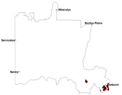 |
The granites generally have developed sandy soils, with profiles varying from uniform or weakly gradational sands (Kandosols) to strongly texture contrast ferruginised (‘buckshot’ or iron pan) soils (Chromosols and Kurosols). The yellow texture contrast soils are strongly acidic at the surface, becoming slightly acidic or neutral at depth. Weakly structured surfaces overlie a massive horizon with variable amounts of coarse quartz fragments. Subsoils are medium to heavy clays often with conspicuous mottling. Total soil depth is variable depending upon differential weathering but generally increase with decrease in topographic position.
Vegetation is dominated on the Mount Cole Granitic Suite by Grassy Dry Forest. Other vegetation communities present include Herb-rich Foothill Forest, Hills Herb-rich Woodland, Grassy Woodland and Alluvial Terraces Herb-rich Woodland/Plains Grassy Woodland Complex. The Black Range has a similar variety of remnant vegetation communities, however it is more exposed to prevailing winds from the north, south and west. Riparian Scrub, Shallow Sands Woodland, Creekline Grassy Woodland and Heathy Woodland are variants.
Groundwater migrates through aquifers comprising either abundant colluvium found on slopes or underlying weathered and fractured/jointed bedrock. Shallow perched groundwater through lateral flow migrates downslope and discharges at the break-of-slope or feeds into basal aquifers that underlie adjacent valleys (WCMA 2005).
The eroding granitic slopes are extremely vulnerable to extreme rainfall events in the form of sheet and rill erosion. Landslides and mud flows can eventuate where extreme rainfall events are coupled with land clearance and steep slopes. Landslips and mudflows occur where saturated soils fail.
Soil-landform unit | Unit description | Area (km2) |
| Langi Ghiran ranges | Granitic mountains | 121 |
| Sugarloaf granite hills | Granitic hills | 26 |
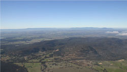
Figure 5 Eastern Black Range, south of Stawell
© State of Victoria (Agriculture Victoria) 1996 - .

This work, Victorian Resources Online, is licensed under a Creative Commons Attribution 4.0 licence. You are free to re-use the work under that licence, on the condition that you credit the State of Victoria (Agriculture Victoria) as author, indicate if changes were made and comply with the other licence terms.
The licence does not apply to ‘branding’ or some ‘images or photographs’ that may be owned by third parties. We ask you to seek prior approval to use images using the VRO feedback form. Access to higher quality images can also be provided on request.
This page was last updated on .