
Soil/Landform Unit - Rhymney hills
Landform Unit Description
Page top
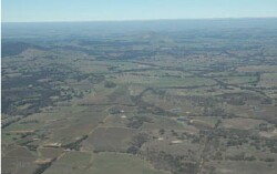 View south towards the low hills near Rhymnay with prominent strike ridges of the Ararat Hills |
0.78% of CMA region These low hills and associated ridges and valleys of predominantly Palaeozoic metasediments occur as foothills flanking the Ararat Hills. There is high granitic terrain (Sugarloaf) to the north and lower erosional and depositional rises and alluvial plains to the west and north-east. Upper and lower slopes are major land components with strike ridges, flats and drainage lines. Drainage dissects this landscape, concentrating flow and increasing the susceptibility to gully erosion. Red texture contrast soil (generally sodic) and yellow and brown sodic texture contrast soils (Sodosols) occur on the lower slopes and flats (less drainage). Sheet and rill erosion, along with gully erosion are potential land threats given the texture contrast nature of soils. The hills are used for grazing (sheep, beef cattle), with occasional dryland cropping on the flats and lower slopes. Woodland communities such as Plains Grassy Woodland, Alluvial Terraces Herb-rich Woodland, Creekline Grassy Woodland, Granitic Hills Woodland and Grassy Woodland dominate remnant vegetation. |  |
 undulating rises and low hills | 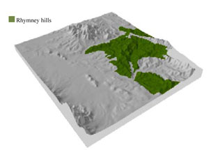 |
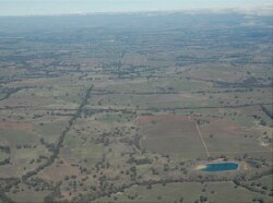
 |  Norval Dam surrounded by remnant vegetation |
Component | 1 | 2 | 3 | 4 | 5 |
Proportion of soil-landform unit | 15% | 15% | 15% | 35% | 20% |
| CLIMATE Rainfall (mm) | Annual: 640 | ||||
| Temperature (oC) | Minimum 7, Maximum 19 | ||||
| Precipitation less than potential evapotranspiration | October-March | ||||
| GEOLOGY Age and lithology | Cambrian basalt, andesite, boninite, rhyolite, gabbro and lithics; Cambrian marine sandstone, siltstone and biotite schist (St Arnaud Group); Neogene fluvial gravel, sand and silt | ||||
| Geomorphology | |||||
| LANDUSE | Uncleared areas: nature conservation Cleared areas: sheep and beef cattle grazing; dryland cropping | ||||
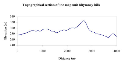
| TOPOGRAPHY Landscape | Undulating low hills | ||||
| Elevation range (m) | 227-428 | ||||
| Local relief (m) | 30–50 | ||||
| Drainage pattern | Dendritic | ||||
| Drainage density (km/km2) | 1.8 | ||||
| Landform | Strike ridges | Low hills | |||
| Landform element | Strike ridge | Drainage line | Flat | Upper slope | Lower hillslope |
| Slope and range (%) | 17 (10-35) | 5 (3-10) | 2 (1-3) | 8 (5-15) | 5 (2-8) |
| Slope shape | Convex | Convex | Concave | Convex | Concave |
| NATIVE VEGETATION Ecological Vegetation Class | Grassy Dry Forest (38.7%), Grassy Woodland (27.4%), Alluvial Terraces Herb-rich Woodland (19.3%), Other (14.0%) | ||||
| SOIL Parent material | In situ biotite schist, marine sandstone and siltstone | Alluvial gravel, sand and silt | Fluvial gravel, sand and silt | In situ biotite schist, marine sandstone and siltstone, minor granite | In situ biotite schist, marine sandstone and siltstone, minor granite |
| Description (Corangamite Soil Group) | Red texture contrast soils (1) | Sodic yellow texture contrast soils (4) | Sodic yellow texture contrast soils (4) | Red texture contrast soils (1) | Red texture contrast soils (1) |
| Soil type sites | LP83, DOAGW31, LP82 | GW28, GW30 | GW28, GW30 | LP83, DOAGW31, LP82 | LP83, DOAGW31, LP82 |
| Surface texture | Fine sandy loam | Sandy loam (silty) | Sandy loam (silty) | Fine sandy loam | Fine sandy loam |
| Permeability | Moderate to high | Slow | Slow | Moderate to high | Moderate |
| Depth (m) | < 0.5 | > 2 | 2 | 1.2 | 1.5 |
| LAND CHARACTERISTICS, POTENTIAL AND LIMITATIONS Critical land features, processes, forms | Friable with better infiltration in moister areas, hardsetting and more prone to sheet and rill erosion in drier areas (north and westerly aspects). Susceptible to acidification in wetter areas. | Light loose surface soils susceptible to periodic inundation, waterlogging and soil salinity. Sodic subsoil susceptible to gully erosion. Poor subsurface drainage, particularly on flats and drainage depressions. Surface soils susceptible to acidification. | Light loose surface soils susceptible to periodic inundation, waterlogging and soil salinity. Sodic subsoil susceptible to gully erosion. Poor subsurface drainage. Surface soils susceptible to acidification. | Friable with better infiltration in moister areas, hardsetting and more prone to sheet and rill erosion in drier areas (north and westerly aspects). Susceptible to acidification in wetter areas. | Friable with better infiltration in moister areas, hardsetting and more prone to sheet and rill erosion in drier areas (north and westerly aspects). Susceptible to acidification in wetter areas. |
© State of Victoria (Agriculture Victoria) 1996 - .

This work, Victorian Resources Online, is licensed under a Creative Commons Attribution 4.0 licence. You are free to re-use the work under that licence, on the condition that you credit the State of Victoria (Agriculture Victoria) as author, indicate if changes were made and comply with the other licence terms.
The licence does not apply to ‘branding’ or some ‘images or photographs’ that may be owned by third parties. We ask you to seek prior approval to use images using the VRO feedback form. Access to higher quality images can also be provided on request.
This page was last updated on .