
5.1.3 Linear dunes sub-dominant (Lowan salt valley, Antwerp)
|
Around Peppers Plains (west of Jeparit) and also buffering the western side of the Wimmera River, a regular series of northnorth- west to south-south-east trending ridges upon which east-west dunes are superimposed represents margin (transition) between what was known as the Northern Wimmera and Southern Mallee. | 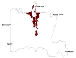 |
Native vegetation dominated by mallee except on dune crests where mallee savannah occurs (Rowan & Downes 1963). Vegetation includes woodlands, mallee and shrubland. Some of the more prevalent vegetation communities include Low Rises Woodland, Lowan Sand Mallee, Sandstone Ridge Shrubland, Ridged Plains Mallee, Parilla Mallee, Red Swale Mallee, Woorinen Mallee, Ridged Plains Mallee, Plains Woodland, Lignum Swampy Woodland, Shallow Sands Woodland and Plains Savannah. Overall, remnant vegetation is small mallee with porcupine grass understorey. Pine and belah woodlands occur widely on high ridges where grasslands are also common. In these areas the soils are mostly red brown medium-textured calcarosols.
The land is mostly devoted to agriculture. The overall erosion hazards of the landscapes are reduced by the lower proportion of dunes and by the widespread clay soils. However, the salinity hazard is severe in the southern Mallee where the rainfall is higher. Water seeps from the dunes perched on clay layers of low permeability, raising the watertable beneath the swales where soluble salt contents are high (Rowan 1971). Evaporation produces saline surfaces. Reclamation involves reducing seepage withdeep-rooted species on the dunes. Yields are also reduced by the inherent salinity of the clay soils, particularly on gilgai puffs. In addition, sodicity at the surface of puffs impairs tilth.
Soil-landform unit | Unit description | Area (km2) |
| Dimboola rises | Gently undulating rises | 166 |
| Hopetoun rises and swales | Undulating rises | 329 |
| Horsham lake and lunettes | Lake and lunette | 3 |
| Horsham lake-lunette cluster | Lake-lunette cluster | 2 |
| Kiata rises | Gently undulating rises | 64 |
| Lowan Salt Valley | Valley plain | 349 |
| Murra Warra West gentle rises | Gentle rises | 9 |
| Nhill lake and lunettes | Lake-lunette | 13 |
| Perenna undulating sand plains and rises | Gently undulating sand plains | 85 |
| Quantong dunes and swales | Dune and swale | 4 |
| Vectis undulating rises and low hills | Undulating rises and low hills | 119 |
| Werrap lake-lunettes | Lake-lunette complex | 4 |
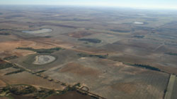
Figure 12 Sequence of lakes and lunettes (gypseous) north-east of Gerang Gerung on the western side of the Wimmera River
© State of Victoria (Agriculture Victoria) 1996 - .

This work, Victorian Resources Online, is licensed under a Creative Commons Attribution 4.0 licence. You are free to re-use the work under that licence, on the condition that you credit the State of Victoria (Agriculture Victoria) as author, indicate if changes were made and comply with the other licence terms.
The licence does not apply to ‘branding’ or some ‘images or photographs’ that may be owned by third parties. We ask you to seek prior approval to use images using the VRO feedback form. Access to higher quality images can also be provided on request.
This page was last updated on .