
2.2.1 Cuesta landscapes (Mount Difficult Range, Mount William Range)
|
The striking cuesta and vale topography of the Grampians Ranges occur within the western extents of the Midlands of Victoria. Extending from Mount William in the south to Mount Zero in the north, the Mount Difficult and Mount William ranges provide spectacular relief over surrounding landscapes of gentle to undulating topography that have defined drainage networks supplying the Wimmera River in the north. | 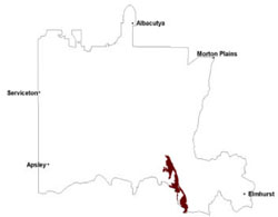 |
The Grampians Group (Spencer Jones 1965) comprises a rock sequence with a stratigraphic succession of quartzo-feldspathic to micaceous sandstone overlain by a micaceous mudstone and finally a quartzose sandstone package (Cayley & Taylor 2001). Latest interpretation of these sedimentary stacks has a number of thrust faults that have intersected this sequence and juxtaposed the stratigraphy in a repetition of strike ridges and valleys through differential erosion. Formed during the late Ordovician to early Silurian, the sediments of the ranges belong to the Red Man Bluff Subgroup and Mount Difficult Subgroup with a cumulative stratigraphic thickness of 3700 m.
Narrow intermontane valleys with subsequent streams occur between the classical cuesta landform patterns of the strike ridges that host significant deposits of colluviium and alluvium from dip slopes and scarps. Jointing and faulting has resulted in significant dissection of the stratigraphic sequence controlling stream pattern density across and along slopes. Stream pattern drainage of the tributaries is pinnate in nature with steep slopes supporting major stream courses running perpendicular to dip slopes. Easterly facing cliffs and steep slopes, along with westerly dipping rock slopes have thin to non-existent regolith and soil development that are sandy. Flat to gently sloping topography has been found with pronounced weathering profiles. The Major Mitchell Plateau and Mount William are possibly the only remnants of the once extensive Mesozoic palaeosurface (Hills 1975; Cayley & Taylor 1997). The ranges are likely to have been exposed in early Cainozoic times as a series of arcuate ridges with the topography more pronounced with further dissection and erosion of less resistant beds of the repeated sedimentary stack.
With the high proportion of rock outcrop, fresh and shallow soils (Rudosols) are common with sandy soils (Tenosols, Kandosols) occurring on mid to lower slopes and texture contrast soils, often acidic on the lower slopes (Kurosols), where there is some clay accumulation in the subsoil. All soils have high concentrations of coarse and fine sand that have extremely high rates of infiltration and allow rapid drainage.
A number of woodland, forest, shrubland and heathland vegetation communities have been recorded including Lowland Forest, Heathy Dry Forest, Rocky Outcrop Shrubland, Heathy Woodland, Rocky outcrop Shrubland/Rocky Outcrop Herbland Mosaic, Shallow Sands Woodland and Sedgy Riparian Woodland. Native vegetation is well preserved within these landscapes with wet and dry sclerophyll forests dominated by brown stringybark (Eucalyptus baxteri), messmate (Eucalyptus obliqua), long leaf box (Eucalyptus goniocaylx) and heath understorey.
Fire is a rather unique feature that has been common throughout the European settlement of the ranges as well as in pre-European times when the Jardwadjali tribe occupied these ranges. Erosional events often occur post fire events where understorey is removed leaving vulnerable sandy topsoils exposed to extreme rainfall events and significant wind from the south and west. Landslip scars on the south facing scarp of the Mount Difficult Range near Halls Gap also highlight failures of shallow soils that have been saturated. Rock falls are extremely infrequent and are mainly confined to scarps and cliffs of south and easterly facing rock exposures.
Soil-landform unit | Unit description | Area (km2) |
| Grampians Ranges | Mountains | 291 |
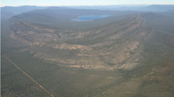
Figure 7 Wartook syncline from the northern end of the Grampians Ranges
© State of Victoria (Agriculture Victoria) 1996 - .

This work, Victorian Resources Online, is licensed under a Creative Commons Attribution 4.0 licence. You are free to re-use the work under that licence, on the condition that you credit the State of Victoria (Agriculture Victoria) as author, indicate if changes were made and comply with the other licence terms.
The licence does not apply to ‘branding’ or some ‘images or photographs’ that may be owned by third parties. We ask you to seek prior approval to use images using the VRO feedback form. Access to higher quality images can also be provided on request.
This page was last updated on .