
Soil/Landform Unit - Drung alluvial plains
 Wimmera River upstream of Glenorchy |
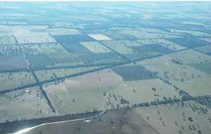
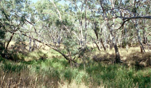
1.49% of CMA region The Wimmera River from Greens Creek to Natimuk is defined as the Drung alluvial plains. These plains form part of the plains without leveed channels of the Older Alluvial Plains geomorphology sequence within the region. Alluvial plains are characterised by backplains with flats, slopes and stream channels while the modern drainage system has prominent stream banks, channels and drainage lines. Soils of these backplains and modern drainage systems comprise sodic grey texture contrast soils (Sodosols) and cracking clay soils (Vertosols) depending upon landform component and topographic position. Woodlands are the dominant vegetation type, including communities such as Riverine Chenopod Woodland, Plains Grassy Woodland, Sand Ridge Woodland and Shallow Sands Woodland. Wetlands also occur and are found in creeklines and swampy areas. Land use on these alluvial plains includes dryland cropping, pasture production (including lucerne), residential development and recreational activities (especially around Horsham). | 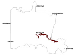 |
 Alluvial floodplain of the Wimmera River at Campbells Bridge | 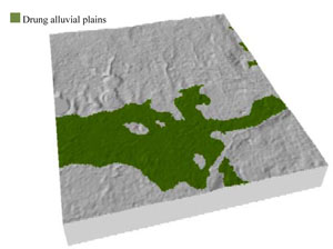 |
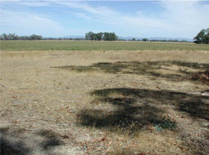
 |  Wimmera River at Glenorchy |
Component | 1 | 2 | 3 | 4 | 5 |
Proportion of soil-landform unit | 50% | 30% | 5% | 5% | 10% |
| CLIMATE Rainfall (mm) | Annual: 495 | ||||
| Temperature (oC) | Minimum 8, Maximum 21 | ||||
| Precipitation less than potential evapotranspiration | September–April | ||||
| GEOLOGY Age and lithology | Quaternary fluvial silt, sand and minor gravel (Shepparton Formation); Quaternary fluvial gravel, sand and silt; Neogene fluvial gravel, sand and silt; Cambrian marine sandstone, siltstone and biotite schist (St Arnaud Group) | ||||
| Geomorphology | |||||
| LANDUSE | Uncleared areas: water supply; nature conservation Cleared areas: dryland cropping; lucerne; sheep and beef cattle grazing; dairy farming; water supply | ||||
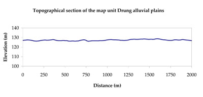
| TOPOGRAPHY Landscape | Alluvial floodplain | ||||
| Elevation range (m) | 114–229 | ||||
| Local relief (m) | 2 | ||||
| Drainage pattern | Dendritic | ||||
| Drainage density (km/km2) | 1.2 | ||||
| Landform | Backplains | Drainage systems | |||
| Landform element | Flat | Gentle slope | Stream channel | Bank | Drainage line |
| Slope and range (%) | 0 (0-1) | 1 (0-3) | 1 (0-1) | 1(0-2) | 1 (0-3) |
| Slope shape | Straight | Straight | Straight | Convex | Concave |
| NATIVE VEGETATION Ecological Vegetation Class | Plains Woodland (39.6%), Riverine Chenopod Woodland (17.8%), Riparian Woodland (17.5%), Other (25.2%) | ||||
| SOIL Parent material | Fluvial gravel, sand and silt | Sandstone, siltstone, greenstone and biotite schist | Fluvial gravel, sand and silt | Fluvial gravel, sand and silt | Fluvial gravel, sand and silt |
| Description (Corangamite Soil Group) | Cracking clay soils (22) | Sodic red texture contrast soils (25) | Sodic grey texture contrast soils (21) | ||
| Soil type sites | WIA20, WIA22 | ||||
| Surface texture | Medium clay | Fine sandy loam | Sandy clay loam | Sandy clay loam to medium clay | Sandy clay loam to medium clay |
| Permeability | Very slow | Slow | Slow | Slow | Slow |
| Depth (m) | > 2 | > 2 | > 3 | > 3 | > 3 |
| LAND CHARACTERISTICS, POTENTIAL AND LIMITATIONS Critical land features, processes, forms | Flat areas susceptible to inundation and waterlogging, but can be variable locally due to micro relief (gilgai). Slightly susceptible to gully erosion where dispersive subsoils are exposed. Surface soils are susceptible to compaction (less structure) at relevant moisture contents. | Hardsetting soil slightly susceptible to sheet and rill erosion. Soils are prone to compaction at critical moisture contents. Subsoil susceptible to gully erosion when exposed due to dispersive (sodic) nature. Slight susceptibility to acidification of surface soil. | Depressions are susceptible to seasonal inundation and waterlogging. Soil compaction can occur at critical moisture contents. | Banks are vulnerable to erosion from significant stream flows and flood events. Here sodic subsoils and hardsetting surface soils are extremely susceptible to stream and overbank erosion. | Depressions are susceptible to seasonal inundation and waterlogging. Soil compaction can occur at critical moisture contents. |
© State of Victoria (Agriculture Victoria) 1996 - .

This work, Victorian Resources Online, is licensed under a Creative Commons Attribution 4.0 licence. You are free to re-use the work under that licence, on the condition that you credit the State of Victoria (Agriculture Victoria) as author, indicate if changes were made and comply with the other licence terms.
The licence does not apply to ‘branding’ or some ‘images or photographs’ that may be owned by third parties. We ask you to seek prior approval to use images using the VRO feedback form. Access to higher quality images can also be provided on request.
This page was last updated on .