
Soil/Landform Unit - Joel south hills
 The cleared hills of this landscape are extremely vulnerable to gully and tunnel erosion |
0.18% of CMA region As part of the Dissected Western Uplands, this group of hills is slightly lower in elevation and has slightly less steep slopes than those of the Pyrenees Ranges. These hills have been largely cleared which makes them distinct from the predominantly uncleared remainder of the Pyrenees Ranges. Hillslopes, colluvial footslopes and drainage depressions are well defined on these hills where gully and tunnel erosions are major limitations and threats. Subsoils are extremely prone to gullying where exposed due to the poor aggregate stability of subsoils. Land use is mainly grazing however dryland cropping and recently viticulture are more common especially on footslopes. Remnant native vegetation communities recorded include Heathy Dry Forest, Grassy Forest, Box Ironbark Forest, Hillcrest Herb-rich Woodland and Grassy Woodland. |  |
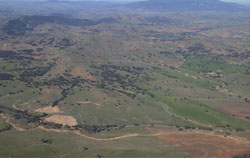
 Looking south from Landsborough West | 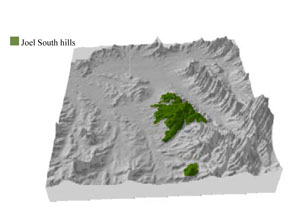 |
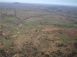
 | 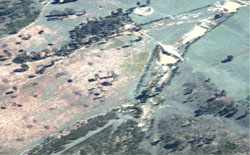 Erosion control works on extremely erosive hillslopes |
Component | 1 | 2 | 3 | 4 | 5 |
Proportion of soil-landform unit | 15% | 20% | 30% | 20% | 15% |
| CLIMATE Rainfall (mm) | Annual: 620 | ||||
| Temperature (oC) | Minimum 8, Maximum 19 | ||||
| Precipitation less than potential evapotranspiration | October–April | ||||
| GEOLOGY Age and lithology | Quaternary fluvial gravel, sand and silt; Cambrian marine sandstone, siltstone and biotite schist (St Arnaud Group); Devonian granite (Ben Nevis Granite) | ||||
| Geomorphology | |||||
| LANDUSE | Uncleared areas: nature conservation Cleared areas: dryland cropping; sheep grazing; viticulture | ||||
| TOPOGRAPHY Landscape | Hills and crests | ||||
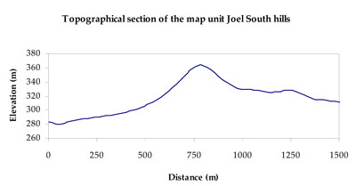
| Elevation range (m) | 229–469 | ||||
| Local relief (m) | 80–120 | ||||
| Drainage pattern | Dendritic | ||||
| Drainage density (km/km2) | 0.7 | ||||
| Landform | Hills and hillslopes | Colluvial footslopes | Drainage lines | ||
| Landform element | Steep crest | Upper slope | Mid slope | Lower slope | Drainage depression |
| Slope and range (%) | 25 (20-40) | 20 (10-35) | 12 (3-20) | 6 (3-18) | 5 (2-20) |
| Slope shape | Convex | Convex | Linear | Concave | Concave |
| NATIVE VEGETATION Ecological Vegetation Class | Box Ironbark Forest (30.7%), Heathy Dry Forest (24.3%), Grassy Dry Forest (16.7%), Other (7.2%) | ||||
| SOIL Parent material | In situ marine sandstone, siltstone and biotite schist and intrusive granites | In situ marine sandstone, siltstone and biotite schist and intrusive granites | In situ marine sandstone, siltstone and biotite schist and intrusive granites | Colluvial and alluvial gravel, sand and silt | Alluvial gravel, sand and silt |
| Description (Corangamite Soil Group) | Red texture contrast soils (1) | Red texture contrast soils (1) | |||
| Soil type sites | |||||
| Surface texture | Fine sandy loam | Fine sandy loam | Sandy loam | Fine sandy loam - silty loam | Fine sandy loam - silty loam |
| Permeability | Moderate | Moderate | Moderate | Moderate to slow | Slow |
| Depth (m) | 0.7 | 0.7 | 0.7 | 0.7-1.4 | 1.5 |
| LAND CHARACTERISTICS, POTENTIAL AND LIMITATIONS Critical land features, processes, forms | Friable with better infiltration in moister areas, hardsetting and more prone to sheet and rill erosion in drier areas (north and westerly aspects). Susceptible to acidification in wetter areas. | Friable with better infiltration in moister areas, hardsetting and more prone to sheet and rill erosion in drier areas (north and westerly aspects). Susceptible to acidification in wetter areas. | Soils may be friable with better infiltration in moister areas, hardsetting and more prone to sheet and rill erosion in drier areas (including drier aspects). Sodic subsoil prone to gully and tunnel erosion. Susceptible to acidification in wetter areas. | Soils are friable with better infiltration in moister areas, hardsetting and more prone to sheet and rill erosion in drier areas (including drier aspects). Sodic subsoil prone to gully and tunnel erosion. Susceptible to acidification in wetter areas. | Soils are friable with better infiltration in moister areas, hardsetting and more prone to sheet and rill erosion in drier areas (including drier aspects). Sodic subsoil prone to gully and tunnel erosion. Susceptible to acidification in wetter areas. |
© State of Victoria (Agriculture Victoria) 1996 - .

This work, Victorian Resources Online, is licensed under a Creative Commons Attribution 4.0 licence. You are free to re-use the work under that licence, on the condition that you credit the State of Victoria (Agriculture Victoria) as author, indicate if changes were made and comply with the other licence terms.
The licence does not apply to ‘branding’ or some ‘images or photographs’ that may be owned by third parties. We ask you to seek prior approval to use images using the VRO feedback form. Access to higher quality images can also be provided on request.
This page was last updated on .