
Soil/Landform Unit - Ararat hills
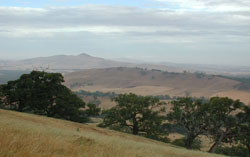 Metamorphosed ridges and hillslopes south of Ararat with Mt Ararat in the distance |
0.23% of CMA region This unit consists of metamorphosed ridges and hillslopes within the upper Wimmera region of the catchment. As part of the Dissected Western Uplands, these north-west to south-east trending strike ridges occur as a series of four parallel ridges with the highest peaks including Mount Ararat (618 m) and One Tree Hill. Slopes are gentle to very steep with the steepest slopes embracing the summit of Mount Ararat. Land use on ridge crests, hillslopes and footslopes varies between remnant vegetation and water supply where land hasn’t been cleared, to residential living and viticulture on more favourable aspects. Soils are dominated by red texture contrast soils (Chromosols) and minor gradational soils (Dermosols) where aspect and rainfall are favourable. Remnant vegetation on exposed slopes and lower altitude areas is dominated by Heathy Dry Forest and Grassy Dry Forest, while other vegetation types found include Rocky Outcrop Shrubland, Alluvial Terraces Herb-rich Woodland and Grassy Woodland. This unit is considered as a high rainfall recharge area with landslides observed as slip scars in the Ararat hills. |  |
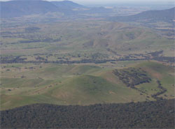 Looking south-east towards cleared hillslops of the Ararat hills | 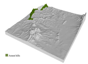 |
|
|

Component | 1 | 2 | 3 |
Proportion of soil-landform unit | 50% | 20% | 30% |
| CLIMATE Rainfall (mm) | Annual: 670 | ||
| Temperature (oC) | Minimum 7, Maximum 19 | ||
| Precipitation less than potential evapotranspiration | October–March | ||
| GEOLOGY Age and lithology | Cambrian marine sandstone, siltstone and biotite schist (St Arnaud Group); Devonian granite | ||
| Geomorphology | |||
| LANDUSE | Uncleared areas: water supply; nature conservation Cleared areas: sheep and beef cattle grazing; dryland cropping; residential development; viticulture | ||
| TOPOGRAPHY Landscape | Strike ridge hills | ||
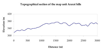
| Elevation range (m) | 280–610 | ||
| Local relief (m) | 120 | ||
| Drainage pattern | Dendritic | ||
| Drainage density (km/km2) | 1.2 | ||
| Landform | Hills | ||
| Landform element | Midslope | Hillcrest and upper slope | Footslope, lower slope and drainage line |
| Slope and range (%) | 30 (20-65) | 8 (2-25) | 7 (5-20) |
| Slope shape | Linear | Convex | Concave |
| NATIVE VEGETATION Ecological Vegetation Class | Grassy Dry Forest (61.9%), Heathy Dry Forest (12.9%), Grassy Woodland/Alluvial Terraces Herb-rich Woodland Mosaic (7.7%), Other (14.7) | ||
| SOIL Parent material | In situ sandstone, siltstone, biotite schist and minor granite | In situ sandstone, siltstone, biotite schist and minor granite | In situ sandstone, siltstone, biotite schist and minor granite |
| Description (Corangamite Soil Group) | Red texture contrast soils (1) | ||
| Soil type sites | |||
| Surface texture | Fine sandy loam | Fine sandy loam | Fine sandy loam to silty loam |
| Permeability | Moderate | Moderate | Moderate to slow |
| Depth (m) | 0.7 | 0.7 | 0.7-1.4 |
| LAND CHARACTERISTICS, POTENTIAL AND LIMITATIONS Critical land features, processes, forms | Soils are friable with better infiltration in moister areas, hardsetting and more prone to sheet and rill erosion in drier areas (including drier aspects). Sodicsubsoil prone to gully and tunnel erosion. Susceptible to acidification in wetter areas. | Friable with better infiltration in moister areas, hardsetting and more prone to sheet and rill erosion in drier areas (north and westerly aspects). Susceptible to acidification in wetter areas. | Soils are friable with better infiltration in moister areas, hardsetting and more prone to sheet and rill erosion in drier areas (including drier aspects). Sodic subsoil prone to gully and tunnel erosion. Susceptible to acidification in wetter areas. |
© State of Victoria (Agriculture Victoria) 1996 - .

This work, Victorian Resources Online, is licensed under a Creative Commons Attribution 4.0 licence. You are free to re-use the work under that licence, on the condition that you credit the State of Victoria (Agriculture Victoria) as author, indicate if changes were made and comply with the other licence terms.
The licence does not apply to ‘branding’ or some ‘images or photographs’ that may be owned by third parties. We ask you to seek prior approval to use images using the VRO feedback form. Access to higher quality images can also be provided on request.
This page was last updated on .