
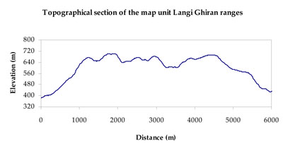
Soil/Landform Unit - Langi Ghiran ranges
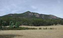
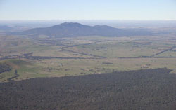 Looking south-east towards Mount Langi Ghiran with the contact metamorphic aureole in the foreground |
0.52% of CMA region Granitic landscapes of the upper Wimmera River catchment are characterised by ridges, escarpments and mountains such as Mount Langi Ghiran. As part of the Dissected Western Uplands, the ranges are noted for the tors and boulders of granite outcrop that are frequent along with cliffs that rise above rock overhangs. Plateau remnants are preserved also on Mount Buangor with gentle slopes surrounded be steep granite margins. The granite of the ranges have developed sandy soils with weakly gradational to uniform profiles, along with yellow texture contrast soils that may become sodic lower in the landscape where rainfall is lower. Light loose surface soils may be susceptible to wind, sheet and rill erosion in drier areas (including drier aspects) when ground coverage is poor. Soil acidification is also probable in wetter areas. Land use is mainly grazing with viticulture well established on northern aspects of the ranges. Vegetation is dominated by Grassy Dry Forest. Other vegetation communities present include Herb-rich Foothill Forest, Hills Herb-rich Woodland, Grassy Woodland and Alluvial Terraces Herb-rich Woodland/Plains Grassy Woodland Complex. | 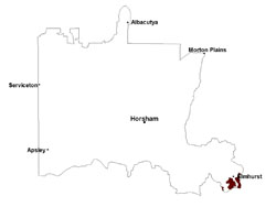 |
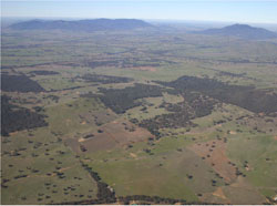 Mount Langi Ghiran with Ben Nevis | 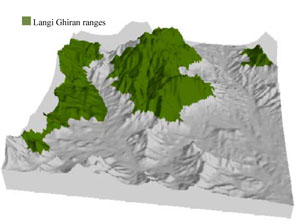 |
 |  Whaleback of Ben Nevis |
Component | 1 | 2 | 3 | 4 | 5 | 6 |
Proportion of soil-landform unit | 5% | 40% | 25% | 15% | 7% | 8% |
| CLIMATE Rainfall (mm) | Annual: 860 | |||||
| Temperature (oC) | Minimum 6, Maximum 17 | |||||
| Precipitation less than potential evapotranspiration | October–March | |||||
| GEOLOGY Age and lithology | Devonian granite; Cambrian marine sandstone, siltstone and biotite schist (St Arnaud Group); Quaternary fluvial gravel, sand and silt | |||||
| Geomorphology | ||||||
| LANDUSE | Uncleared areas: water supply; nature conservation Cleared areas: sheep and beef cattle grazing; water supply | |||||
| TOPOGRAPHY Landscape | Mountains | |||||
| Elevation range (m) | 301–973 | |||||
| Local relief (m) | >300 | |||||
| Drainage pattern | Dendritic | |||||
| Drainage density (km/km2) | 0.8 | |||||
| Landform | Mountain slopes | Plateaux – low hills | Drainage line | |||
| Landform element | Very steep to precipitous slope | Steep slope | Steep slope | Moderate slope | Gentle slope | Drainage line |
| Slope and range (%) | (>50) | 30 (15-50) | 25 (20-35) | 15 (8-30) | 7 (2-25) | 7 (2-50) |
| Slope shape | Straight | Convex | Convex | Convex | Straight | Concave |
| NATIVE VEGETATION Ecological Vegetation Class | Grassy Dry Forest (22.3%), Rocky Outcrop Shrubland/Rocky Outcrop Herbland/Grassy Dry Forest Complex (11.6%), Rocky Outcrop Shrubland/Rocky Outcrop Herbland Mosaic (11.4%), Herb-rich Foothill Forest (10.5%), Other 42.2%) | |||||
| SOIL Parent material | In situ intrusive granite, adamellite and tonalite | In situ intrusive granite, adamellite and tonalite | In situ intrusive granite, adamellite and tonalite | In situ intrusive granite, adamellite and tonalite | Fluvial gravel, sand and silt | Fluvial gravel, sand and silt |
| Description (Corangamite Soil Group) | Yellow texture contrast soils (3) | Yellow texture contrast soils (3) | Yellow texture contrast soils (3) | Yellow texture contrast soils (3) | Yellow texture contrast soils (3) | |
| Soil type sites | ||||||
| Surface texture | Silty loam (sandy) to coarse sandy loam | Silty loam (sandy) to coarse sandy loam | Silty loam (sandy) to coarse sandy loam | Silty loam (sandy) | Silty loam (sandy) | Clayey coarse sand to silty loam |
| Permeability | Slow | Slow | Slow | Slow | Slow | Slow to very slow |
| Depth (m) | < 0.5 | 0.7 | 0.7 | 0.9 | 1.5 | 0.5-3 |
| LAND CHARACTERISTICS, POTENTIAL AND LIMITATIONS Critical land features, processes, forms | Light sandy soils subject to mass movement (creep and sheet flow) on very steep slopes. Loose surface soils are susceptible to wind, sheet and rill erosion in drier areas (including drier aspects) that lack vegetation coverage. Drainage is rapid owing to very steep slopes. Susceptible to acidification in wetter areas. | Light sandy soils subject to mass movement (creep and sheet flow) on very steep slopes. Loose surface soils are susceptible to wind, sheet and rill erosion in drier areas (including drier aspects) that lack vegetation coverage. Drainage is rapid owing to very steep slopes. Susceptible to acidification in wetter areas. | Loose surface soils are susceptible to wind, sheet and rill erosion in drier areas (including drier aspects) that lack vegetation coverage. Drainage is rapid owing to very steep slopes. Susceptible to acidification in wetter areas. | Light loose surface soils that may be susceptible to wind, sheet and rill erosion in drier areas (including drier aspects). Susceptible to acidification in wetter areas. | Light loose surface soils that may be susceptible to wind, sheet and rill erosion in drier areas (including drier aspects). Subsurface drainage may be variable, particularly on gentle slopes. Susceptible to acidification in wetter areas. | Light loose surface soils susceptible to wind, sheet and rill erosion in drier areas (including drier aspects). Sodic subsoil susceptible to gully erosion. Poor subsurface drainage, particularly on flats and drainage depressions. |
© State of Victoria (Agriculture Victoria) 1996 - .

This work, Victorian Resources Online, is licensed under a Creative Commons Attribution 4.0 licence. You are free to re-use the work under that licence, on the condition that you credit the State of Victoria (Agriculture Victoria) as author, indicate if changes were made and comply with the other licence terms.
The licence does not apply to ‘branding’ or some ‘images or photographs’ that may be owned by third parties. We ask you to seek prior approval to use images using the VRO feedback form. Access to higher quality images can also be provided on request.
This page was last updated on .