
5.5.2 Low ridge tops with remnant aeolian sand and oriented swales with lakes and lunettes (south of Little Desert - Kowree, Goroke)
|
This unit is located in western Victoria, clearly bounded by the Big Desert to the north and the little Desert to the south. The South Australian border is the artificial western boundary and the Wimmera River Valley (Lowan Salt Valley) is the eastern boundary. Similar terrain is found to the south of the Little Desert. | 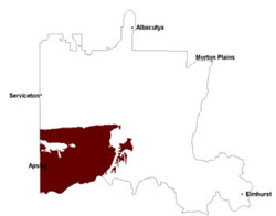 |
Sandy surfaced sodic texture contrast soils (Sodosols) and sandy soils (Rudosols and Tenosols) are generally acidic and occur on the Parilla Sand exposures while sodic (and calcareous) red texture contrast soils occur on the Woorinen Formation material, mainly on the smaller ridges. Grey and black cracking clay soils (Vertosols) formed on lagoonal deposits dominate the swales and valley floors. Vegetation is dominated by woodland and wetlands on expansive plains including Plains Woodland, Shallow Sands, Damp Sands Herb-rich Woodland and Red Gum Wetland. Plains Grassy Woodland is found mostly on freely draining soils. Lunette Woodlands, Heathy Woodland, Cane Grass Wetland, Aquatic Herbland, Shallow Sands Woodland and Escarpment Shrubland are also found on these plains. On sandy dunes and rises (ridges), Shallow Sands Woodland, Damp Sands Herb-rich Woodland, Sand Heathland, Plains Grassy Woodland, Low Rises Woodland and Sandstone Ridge Shrubland are prominent. In the poorer drained swales, swamps, depressions and associated plains, Lignum Swampy Woodland, Freshwater Lake Mosaic, Dune Soak Woodland, Brackish Wetland, Plains Savannah, Shallow Sands Woodland, Plains Woodland, Drainage-line Woodland, Heathy Woodland, Brackish Lake Mosaic, Lignum-Cane Grass Swamp Drainage-line Woodland and Red Gum Wetland occur. Yellow box is the dominant primary vegetation on the ridges with some Casaurinas also occuring. The valley floors are dominated by black box as their primary vegetation.
Sheet erosion is relevant to any sloping terrain, with water repellancy as an associated issue in this unit. Wind and gully erosion is a land degradation issue particularly relevant to the larger ridges. Water repellency and infiltration are issues on the red texture contrast soils particularly where surface soil horizons are shallow. Waterlogging may be an issue on the valley floors depending on rainfall events.
The Parilla Sand deposits provide roading material and are a source of heavy minerals (Campbell et al. 2003).
Soil-landform unit | Unit description | Area (km2) |
| Apsley plains | Plain | 441 |
| Benayeo gilgai plains | Plain | 191 |
| Diapur ridge | Undulating stranded beach ridge | 25 |
| Edenhope undulating plains | Plains with subdued ridges | 196 |
| Fairview plains | Gently undulating plains | 20 |
| Goroke plains and rises | Plain with prominent ridges | 537 |
| Horsham lake and lunettes | Lake and lunette | 4 |
| Horsham lake-lunette cluster | Lake-lunette cluster | 4 |
| Kowree undulating sand plains and ridges | Undulating sand plain and ridges | 1059 |
| Rybybolite plains | Plains | 40 |
| Langkoop clay plain | Clay plain | 40 |
| Merryvale lakes and ridges | Lakes and ridges | 14 |
| Minimay plains | Gently undulating plains | 41 |
| Mosquito Creek swamps sand plains | Swampy sandplain | 104 |
| Neuarpur undulating plains | Plains with subdued ridges | 172 |
| Nurcoung plains | Plains | 139 |
| Powers Creek sand plains | Gently undulating sand plains | 79 |
| Ullswater plains and rises | Plains with parallel ridges | 609 |
| West Wimmera wetlands | Lake | 129 |
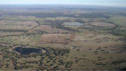
Figure 18 Series of lakes and swamps in swales with sand dunes masked by remnant vegetation near Karnak
© State of Victoria (Agriculture Victoria) 1996 - .

This work, Victorian Resources Online, is licensed under a Creative Commons Attribution 4.0 licence. You are free to re-use the work under that licence, on the condition that you credit the State of Victoria (Agriculture Victoria) as author, indicate if changes were made and comply with the other licence terms.
The licence does not apply to ‘branding’ or some ‘images or photographs’ that may be owned by third parties. We ask you to seek prior approval to use images using the VRO feedback form. Access to higher quality images can also be provided on request.
This page was last updated on .