
Soil/Landform Unit - Six Mile and Seven Mile Creeks
Landform Unit Description
Page top
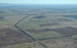 Erosional scars of Six Mile and Seven Mile creeks surrounding the Concongella hills |
0.29% of CMA region The Six Mile and Seven Mile creeks are located east of Stawell and west of the upper Wimmera River. These creeks are drainage pathways for surface flow and groundwaters of the Concongella hills and surrounding rises. Belonging to the terraces and floodplains (2.1.7) division of the Dissected Western Uplands, these plains, flats and drainage depressions are fed from the south, dissect the outwash terrain and flow northward into the broad Wimmera River alluvial plain. Hill slopes and crests, along with rise slopes (upper and lower slopes) contribute to the distinct drainage depressions with drainage lines. Drainage consists of concentrating flow from the Concongella hills and the outwash slopes. Soils include yellow and brown gradational (Dermosols) and texture contrast soil (Chromosols), with sodic brown, yellow and grey texture contrast soils (Sodosols) found in the poorer drained positions. Sheet and rill erosion are potential issues given the texture contrast soils, as is gully erosion. These creeks are used for grazing (sheep, beef cattle), with occasional dryland cropping. Remnant woodland vegetation communities include Heathy Woodland, Plains Grassy Woodland, Alluvial Terraces Herb-rich Woodland, Creekline Grassy Woodland, Grassy Woodland and Plains Woodland. | 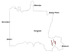 |
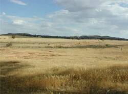 Gully and tunnel erosion at the head of Six Mile Creek | 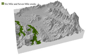 |
 | 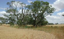 Six Mile Creek |
Component | 1 | 2 |
Proportion of soil-landform unit | 40% | 60% |
| CLIMATE Rainfall (mm) | Annual: 575 | |
| Temperature (oC) | Minimum 8, Maximum 20 | |
| Precipitation less than potential evapotranspiration | October–April | |
| GEOLOGY Age and lithology | Quaternary alluvial gravel, sand and silt; Cambrian marine sandstone, siltstone and biotite schist (St Arnaud Group); Devonian granite (Stawell Granite) | |
| Geomorphology | ||
| LANDUSE | Uncleared areas: nature conservation; water supply Cleared areas: sheep and beef cattle grazing; dryland cropping | |
| TOPOGRAPHY Landscape | Drainage complex | |
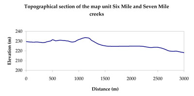
| Elevation range (m) | 195–290 | |
| Local relief (m) | 3 | |
| Drainage pattern | Dendritic | |
| Drainage density (km/km2) | 2.3 | |
| Landform | Alluvial plains–drainage depressions | |
| Landform element | Creek/drainage depression/gully | Alluvial plain |
| Slope and range (%) | 1 (0-2) | 2 (0-5) |
| Slope shape | Concave | Straight |
| NATIVE VEGETATION Ecological Vegetation Class | Grassy Woodland (41.3%), Creekline Grassy Woodland (20.6%), Plains Grassy Woodland (17.1%), Other (19.1%) | |
| SOIL Parent material | Fluvial gravel, sand and silt | Alluvial gravel, sand and silt |
| Description (Corangamite Soil Group) | ||
| Soil type sites | ||
| Surface texture | Loamy sand | Loamy sand |
| Permeability | Moderate to very slow | Moderate to slow |
| Depth (m) | > 2 | > 3 |
| LAND CHARACTERISTICS, POTENTIAL AND LIMITATIONS Critical land features, processes, forms | Lighter surface susceptible to sheet and rill erosion and compaction, especially surfaces with low organic matter. Subsoil susceptible to gully erosion where sodic subsoils are exposed. Lighter variants are well drained. | Lighter surface susceptible to sheet and rill erosion and compaction, especially surfaces with low organic matter. Subsoil susceptible to gully erosion where sodic subsoils are exposed. Lighter variants are well drained. |
© State of Victoria (Agriculture Victoria) 1996 - .

This work, Victorian Resources Online, is licensed under a Creative Commons Attribution 4.0 licence. You are free to re-use the work under that licence, on the condition that you credit the State of Victoria (Agriculture Victoria) as author, indicate if changes were made and comply with the other licence terms.
The licence does not apply to ‘branding’ or some ‘images or photographs’ that may be owned by third parties. We ask you to seek prior approval to use images using the VRO feedback form. Access to higher quality images can also be provided on request.
This page was last updated on .