
4.3 Pediments, alluvial fans and aprons (Glencoe, Yallambee)
|
Higher level alluvial fans and aprons occur predominantly on the south side of the Wimmera River, adjoining the consolidated material of the Western Uplands (units 2.1, 2.2, 2.3) from which they were derived. The alluvial fans and aprons extend from south of Horsham to the Douglas Depression in the west and Dadswells Bridge in the east. The alluvial systems extend south into the Glenelg Hopkins CMA region but finish less than 10 km over the catchment divide. Depth of apron material over the underlying older material (consolidated or not) may vary and may be quite shallow with Neogene ferruginised sediments close to the surface in the Brimpaen area and Grampians sandstone north-west of the western Black Range. Apron and alluvial plain sediments belong to the Shepperton Formation where once extensive fluvial systems extended across much of the Murray Basin. These unconsolidated sediments conformably overlie the Neogene Parilla sand. The lithology of this formation is largely a mix of gravels, sands and silts that through groundwater fluctuations combined with pedogenesis have altered the nature of these sediments. | 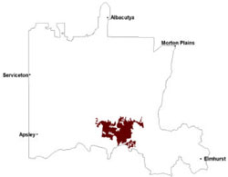 |
The variety of soils which occur on the plain include grey Vertosols, brown Sodosols and yellow and brown Kandosols. Sandsheets (Barrabool map unit) are also present. Within the plain there may be a possible subdivision based on the proportions of Vertosols relative to Sodosols and Kandosols (i.e. the Yallambee with the greater area of Vertosols than the Glencoe map units). Some soil properties may well be limiting factors to primary production. For cereal production these include the coarse blocky structure and the very strong (i.e. very hard) consistence of both surface soils and subsoils of some Vertosols and the strong consistence of the surface soils of some Kandosols.
Remnant vegetation communities on the flat plains and sandy clay plains are dominated by woodlands including Plains Woodland, Shallow Sands Woodland, Damp Sands Herb-rich Woodland, Heathy Woodland, Creekline Sedgy Woodland, Dry Creekline Woodland, Sand Ridge Woodland, Shrubby Woodland, Riparian Woodland, Red Gum Wetland and Plains Grassy Woodland.
Soil-landform unit | Unit description | Area (km2) |
| Barrabool sand plains | Sand plain | 46 |
| Horsham lake and lunettes | Lake and lunette | 16 |
| Horsham lake-lunette cluster | Lake-lunette cluster | 7 |
| Horsham south flat plains | Stagnant alluvial floodplain | 375 |
| Horsham south sand-clay plain | Sand and clay plain | 319 |
| Quantong dunes and swales | Dune and swale | 12 |
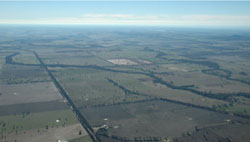
Figure 11 Looking north-east over the alluvial aprons and plains with Mount Zero in the distance
© State of Victoria (Agriculture Victoria) 1996 - .

This work, Victorian Resources Online, is licensed under a Creative Commons Attribution 4.0 licence. You are free to re-use the work under that licence, on the condition that you credit the State of Victoria (Agriculture Victoria) as author, indicate if changes were made and comply with the other licence terms.
The licence does not apply to ‘branding’ or some ‘images or photographs’ that may be owned by third parties. We ask you to seek prior approval to use images using the VRO feedback form. Access to higher quality images can also be provided on request.
This page was last updated on .