
4.1.1 Meander belt below plain level, sometimes source-bordering dunes (Wimmera River, Yarriambiack Creek)
|
This grouping of geomorphological units describes the (generally) youngest spatial landscape feature; the current floodplain of major streams. These units are generally incised into an alluvial plain (unit 4.2) with or without terraces. They are defined as un-confined due to an absence of surrounding uplands, their formation from alluvial material (Coonambidgal Formation), or that they comprise the most recent alluvial landform complex of the WCMA region. | 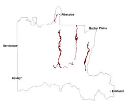 |
Soils vary on the young unconsolidated regolith from sands to loams and clays where finer material has accumulated. There is a higher alkaline component (sodium and calcium) north of Quantong. Major soils include sodic, grey texture contrast soils (grey Sodosols) and cracking clay soils (Vertosols).
The texture contrast soils have slightly acidic sandy clay loam surfaces over grey light clays that increase in sodicity with depth. Minor carbonate occurs in the subsoil. The cracking clays are acidic at the surface with light clays clearly changing to heavy clay subsoils that can be more acidic at depth with very few carbonate nodules. Depths for all soils are generally in excess of 2 m.
Vegetation may also change with climate (drier to the north) though red gums are a major overstorey species. Vegetation communities along these floodplains include a variety of woodlands including Plains Woodland, Drainage-line Woodland, Salt Paperbark Woodland, Lignum Swampy Woodland, Riparian Woodland, Creekline Sedgy Woodland and Riverine Chenopod Woodland for example.
Flooding provides a significant hazard for this unit especially in urban areas along the rivers and creeks. Shrink-swell behaviour of cracking clays around these urban areas may also be a relevant factor in residential development and selection of footings that will accommodate clay expansion and contraction.
Soil-landform unit | Unit description | Area (km2) |
| Wimmera River | River | 197 |
| Yarriambiack / Dunnmunkle Creek | River | 173 |
© State of Victoria (Agriculture Victoria) 1996 - .

This work, Victorian Resources Online, is licensed under a Creative Commons Attribution 4.0 licence. You are free to re-use the work under that licence, on the condition that you credit the State of Victoria (Agriculture Victoria) as author, indicate if changes were made and comply with the other licence terms.
The licence does not apply to ‘branding’ or some ‘images or photographs’ that may be owned by third parties. We ask you to seek prior approval to use images using the VRO feedback form. Access to higher quality images can also be provided on request.
This page was last updated on .