
2.1.1 Ridges, escarpments and mountains on non-granitic Palaeozoic rock (Pyrenees Ranges, Ararat Hills)
|
The ridges, escarpments and mountains are located within the upper catchments of the Wimmera River, Mount William Creek and Mount Cole Creek drainage networks. Occurring throughout the Midlands (including the North Central and Glenelg Hopkins CMA regions), these landscape features often adjoin the hills, rises and plains of similar broad geological lithologies. The Ararat Hills with the Pyrenees Ranges are examples of these Palaeozoic rock landforms. | 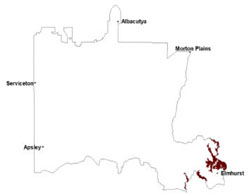 |
The bedrock ridges, fault scarps and monoclines (Joyce 1992) of sedimentary rocks largely consist of sandstones, shales and mudstones that have been intensively folded and faulted in Post-Ordovician times. Later regional and contact metamorphism events saw alteration into metasediments including slates, hornfels, and schists with significant loads of quartz (some gold bearing) as reefs and veins (Sibley 1967).
These landscape elements through differential erosion are remnants of a deeply weathered Palaeogene palaeosurface with rock outcrops fewer and smaller in the north-west of the upper catchment reaches. Depth of regolith is irregular across these landscapes, however the depths are more consistent than sedimentary landscapes with southerly aspects further east. Pallid kaolinitic profiles are often up to 15 m thick with residual ferricrete and reef quartz (Joyce 1992; Taylor & Joyce 1996; Joyce 1998; Carey & Hughes 2002). In some areas, remnants of Palaeogene weathering in the form of siliceous and ferruginous duricrusts are preserved by the inversion of relief and development of structurally bound drainage networks.
Soils that have developed on these landforms are red texture contrast soils (Chromosols) that may be sodic (Sodosols) especially where rainfall is lower and in lower topographic positions. Slightly acidic, they often tend to neutral with depth. Structured surfaces overlie sporadically bleached horizons with variable amounts of coarse weathered bedrock fragments and quartz. Lower slopes have deeper profiles including red-mottled brown and yellow variants.
Heathy Dry Forest and Grassy Dry Forest are found mostly in exposed areas of the Pyrenees Ranges and Ararat Hills, while Herb-rich Foothill Forest, Grassy Dry Forest and Valley Grassy Forest are more closely associated with sheltered steep to very steep hillslopes and drainage lines. Other vegetation communities recorded include Rocky Outcrop Shrubland on ridge crests, Hillcrest Herb-richWoodland, Box Ironbark Forest, Alluvial Terraces Herb-rich Woodland and Grassy Woodland on lower slopes and drainage lines.
As high elevation areas within the WCMA region, hillslopes and crests are considered high rainfall recharge areas with little to no saline discharge within landscapes. Landslides have been observed as slip scars in the Ararat Hills (on the south-eastern slopes of Mount Ararat) where land was cleared as part of historic pastoral runs. The fractured nature of these folded and fractured rocks permits large volumes of groundwater to be stored, and removed from the system usually as break-of-slope events within these local systems.
Soil-landform unit | Unit description | Area (km2) |
| Ararat Hills | Strike ridge hills | 55 |
| Pyrenees Ranges | Mountains | 237 |
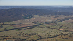
Figure 4 Strike ridges of the Pyrenees Ranges
© State of Victoria (Agriculture Victoria) 1996 - .

This work, Victorian Resources Online, is licensed under a Creative Commons Attribution 4.0 licence. You are free to re-use the work under that licence, on the condition that you credit the State of Victoria (Agriculture Victoria) as author, indicate if changes were made and comply with the other licence terms.
The licence does not apply to ‘branding’ or some ‘images or photographs’ that may be owned by third parties. We ask you to seek prior approval to use images using the VRO feedback form. Access to higher quality images can also be provided on request.
This page was last updated on .