
Soil/Landform Unit - Kanya hills
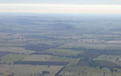 Navarre Hill and the Kanya Hills located in the northern reaches of the upper Wimmera catchment |
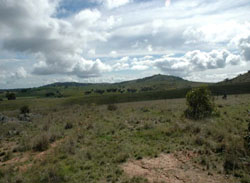
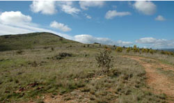
0.05% of CMA region The Kanya hills occur in the upper Wimmera River region on the catchment divide. These Palaeozoic basement rocks form part of the Dissected Western Uplands and include a suite of landform components including hillslopes, hillcrests and drainage depressions. Soils are red to yellow texture contrast soils that may be sodic on lower slopes that have deeper soil profiles. While soil surfaces can be friable (especially in wetter areas), they tend to be sandy, and therefore loose and prone to surface stripping if exposed. The main vegetation communities present are Heathy Dry Forest, Box Ironbark Forest and Hillcrest Herb-rich Woodland. Land use on these low hills is predominantly sheep grazing with some cropping on favourable slopes with greater soil depth. | 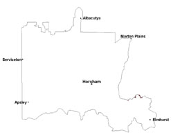 |
 Clear red hills near Landsborough undergoing revegetation | 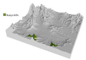 |
 |  Looking east towards Moonambel |
Component | 1 | 2 | 3 | 4 | 5 |
Proportion of soil-landform unit | 10% | 25% | 35% | 20% | 10% |
| CLIMATE Rainfall (mm) | Annual: 535 | ||||
| Temperature (oC) | Minimum 8, Maximum 20 | ||||
| Precipitation less than potential evapotranspiration | September–April | ||||
| GEOLOGY Age and lithology | Cambrian marine sandstone, siltstone and biotite schist (St Arnaud Group); Quaternary fluvial silt, sand and minor gravel (Shepparton Formation) | ||||
| Geomorphology | |||||
| LANDUSE | Uncleared areas: water supply; nature conservation; gravel extraction Cleared areas: dryland cropping; sheep grazing | ||||
| TOPOGRAPHY Landscape | Low hills | ||||
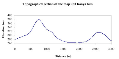
| Elevation range (m) | 226–405 | ||||
| Local relief (m) | 60 | ||||
| Drainage pattern | Dendritic | ||||
| Drainage density (km/km2) | 0.6 | ||||
| Landform | Hills and hillslopes | Drainage lines | |||
| Landform element | Crest | Upper slope | Mid slope | Lower slope | Drainage depression |
| Slope and range (%) | 7 (3-10) | 25 (10-35) | 15 (10-30) | 6 (3-15) | 3 (1-15) |
| Slope shape | Convex | Convex | Convex | Straight | Concave |
| NATIVE VEGETATION Ecological Vegetation Class | Hillcrest Herb-rich Woodland (60.8%), Box Ironbark Forest (23.8%), Heathy Dry Forest (3.6%) | ||||
| SOIL Parent material | In situ marine sandstone, siltstone and biotite schist | In situ marine sandstone, siltstone and biotite schist | In situ marine sandstone, siltstone and biotite schist | In situ marine sandstone, siltstone and biotite schist | Fluvial gravel, sand and silt |
| Description (Corangamite Soil Group) | |||||
| Soil type sites | |||||
| Surface texture | Sandy loam to silty loam | Sandy loam to silty loam | Coarse sandy loam | Coarse sandy loam | Coarse sandy loam |
| Permeability | Moderate to high | Moderate - high | Slow | Slow | Very slow |
| Depth (m) | 0.7 | 1.2 | 1.4 | > 2 | > 2 |
| LAND CHARACTERISTICS, POTENTIAL AND LIMITATIONS Critical land features, processes, forms | Friable with better infiltration in moister areas, hardsetting and more prone to sheet and rill erosion in drier areas (north and westerly aspects). Susceptible to acidification in wetter areas. | Friable with better infiltration in moister areas, hardsetting and more prone to sheet and rill erosion in drier areas (north and westerly aspects). Susceptible to acidification in wetter areas. | Light loose surface soils that may be susceptible to wind, sheet and rill erosion in drier areas (including drier aspects). Poor subsurface drainage, particularly on flats and gentle slopes. Susceptible to acidification in wetter areas. | Light loose surface soils that may be susceptible to wind, sheet and rill erosion in drier areas (including drier aspects). Poor subsurface drainage, particularly on flats and gentle slopes. Susceptible to acidification in wetter areas. | Light loose surface soils that may be susceptible to wind, sheet and rill erosion in drier areas (including drier aspects). Poor subsurface drainage, particularly on flats and gentle slopes. Susceptible to acidification in wetter areas. |
© State of Victoria (Agriculture Victoria) 1996 - .

This work, Victorian Resources Online, is licensed under a Creative Commons Attribution 4.0 licence. You are free to re-use the work under that licence, on the condition that you credit the State of Victoria (Agriculture Victoria) as author, indicate if changes were made and comply with the other licence terms.
The licence does not apply to ‘branding’ or some ‘images or photographs’ that may be owned by third parties. We ask you to seek prior approval to use images using the VRO feedback form. Access to higher quality images can also be provided on request.
This page was last updated on .