Your gateway to a wide range of natural resources information and associated maps

Victorian Resources Online

Sites of Geological and Geomorphological Significance - Westernport Regional

Back to: Port Phillip & Westernport - Sites of Geological and Geomorphological Significance

This is a clickable map. Click site on Legend for more information.
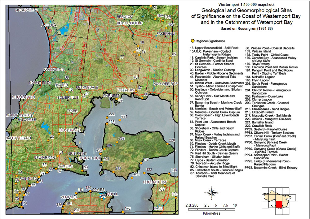
Sites of Geological and Geomorphological Significance - Westernport - Regional
13 Upper Beaconsfield - Split Rock 15 Pakeham - Contact Metamorphic Ridges 18 Cardinia Park - Stream Incision 19 St Germain - Cardinia Sand 20 St Germain - Former Stream Courses 39 Langwarrin - Silurian Outcrop 40 Baxter - Middle Miocene Sediments 41 Pearcedale - Abandoned Tidal Meander 46 Bittern West - Ordovician Sediments 50 Hastings - Ordovician and Silurian Outcrops 51 Tyabb - Minor Terrace Escarpment 53 Sandy Point - Salt Marsh and Relict Spit 57 Balnarring Beach - Merricks Creek Barrier 58 Merricks - Beach and Palmer Bluff 59 Merricks - Coolart Creek Capture 60 Coles Beach - High Level Beach Terrace 61 Point Leo - Abandoned Beach Deposit 63 Shoreham - Cliffs and Beach Ridges 67 Musk Creek - Valley Incision and Raised Beaches 68 Musk Creek - Terraces 70 Flinders - Dodds Creek Mouth 71 Flinders - Marine Cliffs and Bluffs 72 Flinders - Dodds Creek Capture 74 Red Hill South - Baynes Quarry 75 Shoreham - Silurian Inlier 77 Clyde - Baxter Formation 78 Tooradin - Arcuate Ridge 82 Chinaman Island to Blind Bight 85 Pakenham South - Sinuous Ridges 87 Tooradin - Tidal Meanders of Sawtells Inlet 88 Pelican Point - Coastal Deposits 133 Pelican Island 138 Tenby Point - Cliffed Coast 139 Coronet Bay - Abandoned Valley of Bass River 179 Rhyll Swamp 180 Erehwon Point and Mussel Rocks 181 Penguin Point and Red rocks Point - Dipping Tuff Beds 184 McHaffie Lagoon 185 Flynn Lagoon 203 Scrub Point - Ferruginous Sandstone Chilcott Rocks - Ferruginous Sandstone 206 Fairhaven - Dune Lake 208 Clump Lagoon 209 Tankerton Creek - Channel Changes 213 Chesapeake - Sand Ridges 215 Elizabeth Island 217 Mosquito Creek - Salt Marsh 220 Albions - Mangrove Die-back 221 Barrallier Island 222 Crawfish Rock PP62 Seaford - Parallel Dunes PP63 Olivers Hill - Tertiary Sections PP67 Earimil Creek (Dennant Creek) - Manyung Fault PP68 Gunyong (Grices) Creek - Manyung Fault PP69 Gunyong Creek (Grices Creek) - Spinifex Terrace PP74 Schnapper Point - Baxter Sandstone PP75 Linley (Fishermans) Point - Raised Platform PP78 Balcombe Creek - Blind Estuary

Sites of Geological and Geomorphological Significance - Westernport - Regional Significance
13 Upper Beaconsfield - Split Rock87 Tooradin - Tidal meanders of Sawtells Inlet
15a/b/c Pakenham - Contact Metamorphic ridges88 Pelican Point - Coastal deposits
18 Cardinia Park - Stream incision133 Pelican Island
19 St Germain - Cardinia sand138 Tenby Point - Cliffed coast
20 St Germain - Former stream courses139 Coronet Bay - Abandoned valley of Bass River
39 Langwarrin - Silurian outcrop179 Rhyll Swamp
40 Baxter - Middle miocene sediments180 Erehwon Point and Mussel Rocks
41 Pearcedale - Abandoned tidal meander181 Penguin Point and Red rocks Point - Dipping tuff beds
46 Bittern West - Ordovician sediments184 McHaffie Lagoon
50 Hastings - Ordovician sediments 185 Flynn Lagoon
51 Tyabb - Minor terrace escarpment203 Scrub Point - Ferruginous sandstone
53 Sandy Point - Salt marsh and relict spit204 Chilcott Rocks - Ferruginous sandstone
57 Balnarring Beach - Merricks Creek barrier206 Fairhaven - Dune lake
58 Merricks - Beach and Palmer Bluff208 Clump lagoon
59 Merricks - Coolart Creek capture209 Tankerton Creek - Channel changes
60 Coles Beach - High level beach terrace213 Chesapeake - Sand ridges
61 Point Leo - Abandoned beach deposit215 Elizabeth Island
63 Shoreham - Cliffs and beach ridges217 Mosquito Creek - Salt marsh
67 Musk Creek - Valley incision and raised beached220 Albions - Mangrove die-back
68 Musk Creek - Terraces221 Barrallier Island
70 Flinders - Dodds Creek mouth222 Crawfish Rock
71 Flinders - Marine cliffs and bluffsPP62 Seaford - Parallel dunes
72 Flinders - Dodds Creek capturePP63 Olivers Hill - Tertiary sections
74 Red Hill South - Baynes quarryPP67 Earimil Creek (Dennant Creek) - Manyung fault
75 Shoreham - Silurian inlierPP68 Gunyong (Grices) Creek - Manyung fault
77 Clyde - Baxter formationPP69 Gunyong Creek (Grices Creek) - Spinifex terrace
78 Tooradin - Arcuate ridgePP74 Schnapper Point - Baxter sandstone
82 Chinaman Island to Blind BightPP75 Linley (Fishermans) Point - Raised platform
85 Pakenham South - Sinuous ridgesPP78 Balcombe Creek - Blind estuary
Page top