
209. Tankerton Creek - Channel Changes
|
This information has been developed from one or more of these publications:
|
| Location: | Rhyll - 493506. 500 m north of the Tankerton Jetty. | 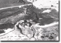 Tankerton Creek. Arrows show undercut banks and dotted line is former shoreline. Truncated meander (A) is a result of shoreline erosion, Site 209 |
Access: | Coast Road. | |
Ownership: | Crown land. | |
Geomorphology: | The lower reaches of Tankerton Creek are tidal and the channel displays tight meander bends. Erosion and undercutting take place on the outside of the meander bends. Shoreline erosion following die-back of mangroves has shortened the length of the creek leaving the former outlet as a truncated meander. | |
Significance: | Regional. The site displays several physiographic changes that can occur as a result of mangrove die-back. | |
Management: | Class 1. As the erosion does not threaten any property, it is not necessary to carry any bank stabilization schemes or to attempt to reduce erosion rates of the coast or the stream channel. | |
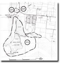 Sites 209 & 210. Tankerton and Tortoise Head area |

© State of Victoria (Agriculture Victoria) 1996 - .

This work, Victorian Resources Online, is licensed under a Creative Commons Attribution 4.0 licence. You are free to re-use the work under that licence, on the condition that you credit the State of Victoria (Agriculture Victoria) as author, indicate if changes were made and comply with the other licence terms.
The licence does not apply to ‘branding’ or some ‘images or photographs’ that may be owned by third parties. We ask you to seek prior approval to use images using the VRO feedback form. Access to higher quality images can also be provided on request.
This page was last updated on .