
PP63. Olivers Hill - Tertiary Sections
|
This information has been developed from one or more of these publications:
|
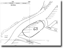
| Location: | 344653. Base of Olivers Hill on the eastern side of the Nepean Highway between Somme Ave and Warringa Road, Frankston. | 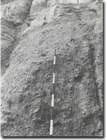 Site 63. Conglomerate bed at Olivers Hill |
Access: | Nepean Highway. | |
Ownership/Managing Authority: | Crown land (Road Construction Authority) and private land. | |
Site Description: | A cliff slope developed by an old landslip at the base of Olivers Hill exposes a Tertiary sediment sequence underlying weathered Older Volcanics basalt. The most distinctive bed, at the base of the section, is a weathered conglomerate with cobbles and boulders of Palaeozoic sandstone, shale, quartzite and slate set in a sandy clay matrix. The conglomerate rests on weathered granite but the contact is obscured by slope wash debris. The sediments dip northward at an angle of about 15 degrees. | |
Significance: | Regional. This is the best exposure of sub-basaltic sediments on the eastern coast of Port Phillip Bay. This is an excellent site to determine the environment of deposition of this material and makes a natural starting point for geological excursions examining the Tertiary geology of the Mornington Peninsula. It has been exposed for at least 90 years and is a stable and accessible site for senior geology students. | |
Management Considerations: | Class 1. The exposure is relatively stable despite the numerous small rills. It should be retained as a geological exposure and not regraded or artificially covered. If highway safety (from slipping or falling material) is perceived as an issue, investigation should be made to providing a protective fence or barrier rather than covering the slope. An elevated, rather than an excavated footpath, would ensure safe access to the lower part of the exposure. | |
References: | Kitson, A.E. (1900). Report on the coastline and adjacent country between Frankston, Mornington and Dromana. Geol. Surv. Vict. Prog. Rep. 12, 1-13. Gostin, V.A. (1966). Tertiary stratigraphy of the Mornington district, Victoria. Proc. R. Soc. Vict., 79, 459-512. | |
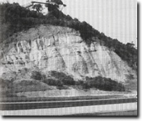 Site 63. Northward dipping Tertiary sediments, Olivers Hill, Frankston |

© State of Victoria (Agriculture Victoria) 1996 - .

This work, Victorian Resources Online, is licensed under a Creative Commons Attribution 4.0 licence. You are free to re-use the work under that licence, on the condition that you credit the State of Victoria (Agriculture Victoria) as author, indicate if changes were made and comply with the other licence terms.
The licence does not apply to ‘branding’ or some ‘images or photographs’ that may be owned by third parties. We ask you to seek prior approval to use images using the VRO feedback form. Access to higher quality images can also be provided on request.
This page was last updated on .