
87. Tooradin - Tidal Meanders of Sawtells Inlet
|
This information has been developed from one or more of these publications:
|
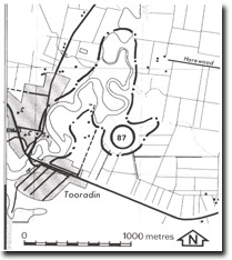
| Location: | Tooradin – 586697. The site extends for 1.7 km north of the South Gippsland Highway bridge across Sawtells Inlet at Tooradin. | 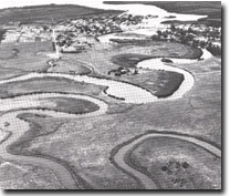 Tidal meanders at Sawtells Inlet, Site 87 |
| Access: | Tooradin Station Road. A small boat may traverse the inlet at high tide. | |
| Ownership: | Crown land (Public Land Water Frontage Reserve), and private land. | |
| Geomorphology: | Sawtells Inlet is a highly sinuous tidal channel upstream from the South Gippsland Highway bridge. The meanders have a radius of curvature of approximately 150 m, and near the bridge are broadly convex. Further inland, the meanders are of the anvil head patter. Flood tidal scour in places is eroding the banks of the channel, and it is probable that some of the meander may become cut-off. | |
| Significance: | Regional. The site is a clear display of the development of flood tide meanders. Because of the large tidal range, this is a useful and accessible site to study tidal flow in a narrow inlet. Unlike most other tidal inlets and creek mouths on the northern shore of Westernport Bay, this site has not been extensively modified by artificial land drainage schemes. | |
| Management: | Class 1. No artificial drainage or erosion control measures should be undertaken at the site. Engineering works or coastal facilities construction should not be permitted if they will cause obstruction to free tidal flow in the main channel. No buildings should be permitted adjacent to the tidal channel. | |

© State of Victoria (Agriculture Victoria) 1996 - .

This work, Victorian Resources Online, is licensed under a Creative Commons Attribution 4.0 licence. You are free to re-use the work under that licence, on the condition that you credit the State of Victoria (Agriculture Victoria) as author, indicate if changes were made and comply with the other licence terms.
The licence does not apply to ‘branding’ or some ‘images or photographs’ that may be owned by third parties. We ask you to seek prior approval to use images using the VRO feedback form. Access to higher quality images can also be provided on request.
This page was last updated on .