
220. Albions - Mangrove Die-back
|
This information has been developed from one or more of these publications:
|
| Location: | Palmer - 670556. North-east coastline of French Island extending for 2 km north-west of Spit Point. | 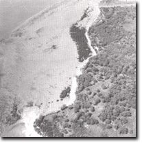 Mangrove die-back south of Albions, Site 220. |
Access: | Causeway Road and walk along the beach from Albions. | |
Ownership: | Crown land. | |
Geology/Geomorphology: | The north-east shoreline of French Island displays a variety of coastal features including cliffs, sandy beaches, pockets of mangroves and salt marsh. The configuration of the shoreline changes abruptly from a mangrove/salt marsh fringe to a sandy shoreline overlying mudflat deposits at a point approximately 3 km south-east of Palmer Point. The geology of the area is of interest for the exposure of deeply weathered Older Volcanics basalt in cliff sections along the coast. The basalt is overlain by a coarse ferruginous sandstone member of the Baxter Formation in a clearly defined contact along the upper section of the cliff exposures. The site includes part of the scarp of the Wellington Fault. | |
Significance: | Regional. This area is one in which the effects of sandy sediments on the mangrove/salt marsh community provide an excellent example of dynamic physiography. Early maps, eg - Smythe 1842, indicated this sector of coastline as being mangrove fringed. The present-day situation is one of small pockets of mangroves alternating with areas of inter-tidal mudflats covered by a variable veneer of sandy sediments. This indicates that a significant change in coastal processes has occurred. | |
The deeply weathered exposure of basalt is significant because it may represent a lava flow of a different Tertiary sequence from those found along the southern shoreline of the island. | ||
Management: | Class 1. To preserve the dynamic nature of the site it is important that sediment movement into and out of the area should not be affected. The construction of groynes or other coastal structures which would either change or impede directions of sediment flow should not be permitted. | |

© State of Victoria (Agriculture Victoria) 1996 - .

This work, Victorian Resources Online, is licensed under a Creative Commons Attribution 4.0 licence. You are free to re-use the work under that licence, on the condition that you credit the State of Victoria (Agriculture Victoria) as author, indicate if changes were made and comply with the other licence terms.
The licence does not apply to ‘branding’ or some ‘images or photographs’ that may be owned by third parties. We ask you to seek prior approval to use images using the VRO feedback form. Access to higher quality images can also be provided on request.
This page was last updated on .