
217. Mosquito Creek - Salt Marsh
|
This information has been developed from one or more of these publications:
|
| Location: | Corinella - 605513 to 593495. Southern coastline of French Island adjacent to the mouth of Mosquito Creek. | 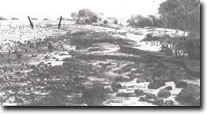 Mangrove stumps (arrowed), eroding and chenier emplacement, Mosquito Creek, Site 217. |
Access: | A sandy vehicle track leads east from the junction of Mosquito Creek Road and Overpass Road directly onto the salt marsh. | |
Ownership: | Crown land. | |
Geology/Geomorphology: | The mouth of Mosquito Creek is estuarine for a short distance. At the head of Dragon Bay a wide strip of salt marsh has developed in front of a low bluff in Baxter Formation sediments. This bluff is continuous with the cliffed shoreline immediately east of the salt marsh deposits. A sequence of three to four low ridges at the base of the bluff represent former sandy beaches which have been isolated from marine erosion by the development of a progradation salt marsh terrace. An early map of coastal vegetation (Smythe 1842) showed a continuous mangrove fringe in front of the salt marsh deposits. The present configuration of the shoreline indicates that removal of a large number of mangroves has occurred, possibly for the production of barilla (Bird 1975). Mangrove stumps are evident along sectors of the shoreline previously mapped as mangrove-fringed, and the outer edge of the former mangrove zone has only a few scattered plants. Pockets of mangroves remain in the sector of shoreline east of the mouth of Mosquito Creek but do not appear to display vigorous regeneration. | |
Chenier formation at the outer edge of the salt marsh is an active process, and can be directly related to the low removal of mangroves. Extensive cliffing of all the salt marsh deposits in this sector of shoreline is a marked feature of the Mosquito Creek salt marsh. | ||
Significance: | Regional. The process of chenier formation is clearly represented at this site. The site is of interest for demonstrating the number of geomorphic processes involved in salt marsh terrace and chenier formation. | |
Management: | To maintain the significance of the site it is important that the natural process be permitted to operate. Drainage, clearing, grazing or construction works should be prohibited. Erosion of salt marsh sediments does not constitute a threat to property and no coastal protection works are considered necessary. | |
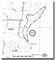 Site 217, Mosquito Creek |

© State of Victoria (Agriculture Victoria) 1996 - .

This work, Victorian Resources Online, is licensed under a Creative Commons Attribution 4.0 licence. You are free to re-use the work under that licence, on the condition that you credit the State of Victoria (Agriculture Victoria) as author, indicate if changes were made and comply with the other licence terms.
The licence does not apply to ‘branding’ or some ‘images or photographs’ that may be owned by third parties. We ask you to seek prior approval to use images using the VRO feedback form. Access to higher quality images can also be provided on request.
This page was last updated on .