
18 Cardinia Park - Stream Incision
|
This information has been developed from one or more of these publications:
|
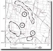
| Location: | Pakenham – 592819. Four kilometres south of Officer. | 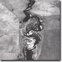 Incised channel of Cardinia Creek - rejuvenated following drainage of swamplands, Site 18. |
| Access: | Officer Road. | |
| Ownership: | Crown Land (Public Land River Frontage). | |
| Geomorphology: | The Cardinia Creek is here deeply incised (in excess of 10 metres) into a former swampy flood plain. The channel in plain view is sinuous and there are steep and slumping bank sectors. The phase of erosion taking place was initiated with the draining of the former swampland over the last 100 years. The eroding channel walls expose the swamp and flood plain sediments. | |
| Significance: | Regional. The site is an example of the impact of the swamp drainage schemes on channel patterns in the northern catchment of Westernport Bay. | |
| Management: | Class 3. The site has been partly man-modified in attempts to control further erosion and reduce the hazard to farming activities. Therefore, while it is of considerable interest to monitor future erosion rates, it is recognised that further control measures that may reduce the significant features of the site may be necessary to reduce the risk of property damage. | |
References: | Bird, E.C.F. & Barson, M.M. (1981). Geomorphological implications of flood control measures, Lang Lang River, Victoria. Aust. Geog. Stud. 169-183. Key, L.M. (1967). Historical geography of the Kooweerup disrict. M.A. thesis (unpub.) Dept. of Geog. Univ. of Melb. | |

© State of Victoria (Agriculture Victoria) 1996 - .

This work, Victorian Resources Online, is licensed under a Creative Commons Attribution 4.0 licence. You are free to re-use the work under that licence, on the condition that you credit the State of Victoria (Agriculture Victoria) as author, indicate if changes were made and comply with the other licence terms.
The licence does not apply to ‘branding’ or some ‘images or photographs’ that may be owned by third parties. We ask you to seek prior approval to use images using the VRO feedback form. Access to higher quality images can also be provided on request.
This page was last updated on .