
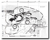
179. Rhyll Swamp
|
This information has been developed from one or more of these publications:
|
| Location: | Rhyll – 495406. 2 km west of Rhyll south of the Cowes Road. | 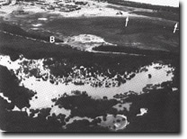 Old sand barrier (B) enclosing Rhyll Inlet. Recurving spit complex (A) and relict spits and beach ridges (B). Arrows indicate bluffs on southern side, Site 179 |
| Access: | Cowes to Rhyll Road. | |
| Ownership: | Crown land. | |
| Geomorphology: | Rhyll Swamp is a freshwater swamp to the south of Rhyll Inlet and separated from the inlet by a ridged barrier of gravelly sand 100 to 400 m wide and up to 2.5 m high (Marsden & Mallett 1975). This barrier has enclosed a former coastal embayment, drainage from the land has been impounded and marine influence excluded from the swamp area for several thousand years. | |
| Significance: | Regional. The margins of the swamp represent former coastlines formed at higher sea levels. They illustrate an early phase in the evolution of Rhyll Inlet. | |
| Management: | Class 2. Extensions to the tip north of the Rhyll to Cowes Road should be prohibited as this is masking the terrain of the ridge. Continued use as wildlife reserve is compatible with retaining the significant geomorphological features. | |
| References: | Marsden, M.A.H. & Mallett, C.W. (1975). Quaternary evolution, morphology and sediment distribution, Westernport Bay, Victoria. Proc. Roy. Soc. Vict. Vol 87 (1) 107-137. | |

© State of Victoria (Agriculture Victoria) 1996 - .

This work, Victorian Resources Online, is licensed under a Creative Commons Attribution 4.0 licence. You are free to re-use the work under that licence, on the condition that you credit the State of Victoria (Agriculture Victoria) as author, indicate if changes were made and comply with the other licence terms.
The licence does not apply to ‘branding’ or some ‘images or photographs’ that may be owned by third parties. We ask you to seek prior approval to use images using the VRO feedback form. Access to higher quality images can also be provided on request.
This page was last updated on .