
PP74. Schnapper Point - Baxter Sandstone
|
This information has been developed from one or more of these publications:
|
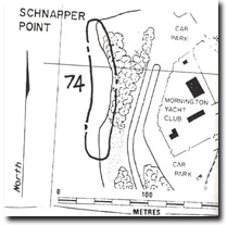
| Location: | 2766885. Northwestern edge of Schnapper Point, Mornington. | 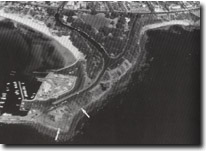 Site 74. Schnapper Point. Raised platform is shown by arrows. |
Access: | Flinders Drive or Schnapper Point Drive, Mornington. | |
Ownership/Managing Authority: | Crown land, Shire of Mornington. | |
Site Description: | At the base of the coastal slope is a low cliff cut in ferruginous sandstone of the Baxter Sandstone, this rock forming angular boulders and blocks on the shoreline. On the bench cut in the sandstone about 1.5 m above high water mark, and overlain by a cemented gravelly deposit of the same material. This may be a raised shore platform with a residual beach deposit. | |
Significance: | Regional. The site is a clear and safely accessible sea level exposure of the structural and textural properties of the Baxter Sandstone. At many other coastal sites, this material is much higher in the cliffs and difficult to examine. The erosional bench (the possible raised platform) is significant in determining the sea level history of Port Phillip Bay. | |
Management Considerations: | Class 1. The site should be left exposed. No landscaping or reclamation of the seaward face of the cliffs should be undertaken. No protective structures or beaches should be built in front of the cliffs. | |
References: | Gostin, V.A. (1966). Tertiary stratigraphy of the Mornington district, Victoria. Proc. R. Soc. Vict., 79, 459-512. | |
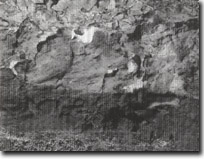 Site 74. Raised platform, Schnapper Point |

© State of Victoria (Agriculture Victoria) 1996 - .

This work, Victorian Resources Online, is licensed under a Creative Commons Attribution 4.0 licence. You are free to re-use the work under that licence, on the condition that you credit the State of Victoria (Agriculture Victoria) as author, indicate if changes were made and comply with the other licence terms.
The licence does not apply to ‘branding’ or some ‘images or photographs’ that may be owned by third parties. We ask you to seek prior approval to use images using the VRO feedback form. Access to higher quality images can also be provided on request.
This page was last updated on .