
PP62. Seaford - Parallel Dunes
|
This information has been developed from one or more of these publications:
|
| Location: | 354819 to 354784. Approximately 4 km of coastal dunes, beach, and near shore sand bars, north and south of Seaford Pier, between Armstrong Road and Overton Road, Seaford. |
Access: | Nepean Highway. |
Ownership/Managing Authority: | Crown land, Seaford Foreshore Committee of Management. |
Site Description: | The site includes a complex of sand ridges that forms part of a barrier system extending from Mordialloc to Frankston that impounds the Carrum Swamp. This sector is the outer barrier and is composed of wind-blown sand overlying stratified beach deposits of sand, waterworn pebbles and marine shells. The higher shell beds (seen only in excavations) are about 1 m above present high water mark. The overlying dune sands form a single irregular ridge parallel with the coastline, and have hummocky sectors where blowouts and deflation hollows have been more recently initiated. Kananook Creek follows a swampy depression between the coastal ridge and a parallel and similar ridge to the east. The dunes carry a Tea-tree and Banksia woodland vegetation with an understorey and fringing community of shrubs, herbs and grasses. The beach outline is sinuous with cusps and berms, and there are conspicuous offshore bars both parallel and oblique to the trend of the coast. |
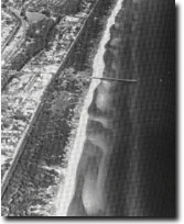 Site 62. Seaford barrier system (bars, beach and dunes). | 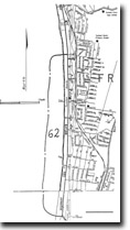 Site 62. Seaford barrier system, bars, beach an dunes | 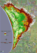 A 1 metre digital elevation model (DEM) of the Frankston to Mordialloc area showing the parallel ridges at Seaford |
| Significance: | Regional. The site is the most intact remnant of the large barrier and wetland complex that dominated the physiography of the area between Mordialloc and Frankston. Drainage schemes and residential development have greatly modified the wetland and barrier terrain. This is the largest barrier system in Port Phillip Bay and the second largest in Victoria after the Gippsland Lakes/Corner Inlet barriers. It is an important area for studies of dune, barrier and bar morphology and evolution. |
Management Considerations: | Class 2. To maintain the dune system, it is necessary to continue protection of the vegetation by excluding all vehicles, motorcycles and horses, and controlling pedestrian movement by fencing. The morphology of the site can only be maintained if there is a viable and regenerating vegetation cover. Extensions to car parking and expansion of visitor amenities should only take place adjacent to existing facilities eg - the Seaford Pier. The offshore bar system is regarded as an integral part of the site, both as a feature of significance and as a component of the beach-dune nourishment system. |
References: | Whincup, S. (1944). Superficial sand deposits between Brighton and Frankston. Proc. R. Soc. Vict., 56, 53-76. Cullen, P. (1973). Coastal conservation problems at Seaford. Vic. Nat. 50, 251-257. |

© State of Victoria (Agriculture Victoria) 1996 - .

This work, Victorian Resources Online, is licensed under a Creative Commons Attribution 4.0 licence. You are free to re-use the work under that licence, on the condition that you credit the State of Victoria (Agriculture Victoria) as author, indicate if changes were made and comply with the other licence terms.
The licence does not apply to ‘branding’ or some ‘images or photographs’ that may be owned by third parties. We ask you to seek prior approval to use images using the VRO feedback form. Access to higher quality images can also be provided on request.
This page was last updated on .