
PP78. Balcombe Creek - Blind Estuary
|
This information has been developed from one or more of these publications:
|
| Location: | 264627. Lower reach of Balcombe Creek at Mt Martha. | 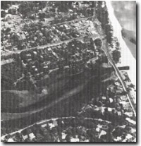 Site 78. Balcombe Creek estuary |
Access: | Mirang Ave off Watson Road. | |
Ownership/Managing Authority: | Crown land, Shire of Mornington (various reserves). | |
Site Description: | The lower reach of Balcombe Creek opens into a broad, shallow tidal lagoon fringed by sedge, reedswamp and swamp scrub. This lagoon is connected to Port Phillip Bay by a sandy channel, deflected and sometimes closed by beach and spit growth. When the entrance is open, the lagoon becomes a broad expanse of mudflat at low tide, drained by shallow channels. | |
Significance: | Regional. This is the only major estuary on the east coast of Melbourne to retain any significant geomorphological values. It is an example of an estuary that is frequently closed by spit growth, the typical situation of small estuaries on the Victorian coast. It illustrates the depositional environment of enclosed lagoons and the role of vegetation in developing estuarine shorelines. | |
Management Considerations: | Class 2. The site should not be dredged, filled or otherwise reclaimed. It should be maintained as a ‘working’ model of the estuarine depositional environment. | |
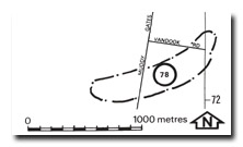
Site 78. Balcombe Creek estuary and lagoon

© State of Victoria (Agriculture Victoria) 1996 - .

This work, Victorian Resources Online, is licensed under a Creative Commons Attribution 4.0 licence. You are free to re-use the work under that licence, on the condition that you credit the State of Victoria (Agriculture Victoria) as author, indicate if changes were made and comply with the other licence terms.
The licence does not apply to ‘branding’ or some ‘images or photographs’ that may be owned by third parties. We ask you to seek prior approval to use images using the VRO feedback form. Access to higher quality images can also be provided on request.
This page was last updated on .